08 – ICONOGRAPHY AND REMOTE SENSING APPLIED TO THE LOCATION OF THE BARRA DO PARÁ FORTRESS
Ano 07 (2020) – Número 01 Artigos
![]() 10.31419/ISSN.2594-942X.v72020i1a8RCCN
10.31419/ISSN.2594-942X.v72020i1a8RCCN
Roseane da Conceição Costa Norata*, Milena Sanae Iwashita Mourab, Alessandro Sabá Leitec Marcondes Lima da Costad
abLACORE/ITEC/UFPA, Mercedários UFPA, Rua Gaspar Viana, 125, Campina, Belém, Pará, Brazil, e-mail: rosenorat@gmail.com a, milenaiwashita@gmail.comb
cdWorkgroup Applied Mineralogy and Geochemistry (GMGA), Geosciences Institute (IG)/Federal University of Pará (UFPA), Belém, Pará, Brazil.
e-mail: alessandro.leite@me.comc, marcondeslc@gmail.comd
*Corresponding author
ABSTRACT
The city of Belém (Pará, Brazil) had a defensive system composed of at least twelve structures such as fortresses, forts or batteries distributed along the continental cliffs and river banks. Among these buildings, the Fortress of Nossa Senhora das Mercês da Barra do Pará or simply Barra do Pará Fortress, whose construction began in 1686 but disappeared after an explosion in 1947. The fortress was configured in a circular structure built on a “stone islet” according to historical descriptions. Its location on an inlet of the Guajará Bay, combined with historically iconographic points of an island formed by the accumulation of silt-sandy sediments having its structural base artificially reinforced with rocks, possibly blocks of ferruginized sandstones, ferruginous lateritic crusts and iron stones, the same materials used in the other fortresses nearby. Given these evidences, this paper aims to identify the precise location of the Barra do Pará Fortress in correlation to the continental portion of the possible remnants of an implantation site based on iconography and recent images of the Earth’s surface generated through orbital satellites. The methodology was based on satellite images generated in the years 2005, 2013, 2014, 2017, 2018 and 2019 and on drawings from the 17th, 18th and 19th centuries. The results point to the possible evidence of this structure in a location signaled with a beacon at the coordinates 1°22’39.50″S and 48°29’34.48″W, about 0.5 kilometers away from the continental margin, close to the current neighborhood of Val-de-Cães.
Keywords: Circular Fortress; Val de Caens; Sand bars; Guajará Bay.
INTRODUCTION
The first settlements for city of Belém (Pará, Brazil) were established in 1616 with the construction of a fort called Forte do Castelo do Senhor Santo Cristo do Presépio de Belém currently known as Castelo Fort (or even Presépio Fort) under the leadership of Francisco Caldeira Castelo Branco, known as city´s found. Through this construction, the Amazon River basin received several other fortifications and advantage points, built especially in the 17th and 18th centuries (Vianna 1905; Meira Filho 2015; Norat & Costa 2016 b).
Over time the city was equipped with a network of other fortified structures, which formed a defensive system on land and at sea. Among these structures there was a fortress of circular configuration, located in the Guajará Bay, called the Fortress of Nossa Senhora das Mercês da Barra do Pará or simply the Barra do Pará Fortress, which functioned in articulation with other structures (Norat & Costa 2016 a; Norat & Costa 2016 b; Norat & Costa 2018). The fortress was built on a “stone islet” according to historical descriptions (Vianna 1905; Barreto 2010; Meira Filho 2015; Norat & Costa 2016 b).
This description refers a location on the inlet of the Guajará Bay formed by the accumulation of silt-sandy sediments (river bars) having its structural base artificially reinforced with rocks, possibly blocks of ferruginized sandstones, ferruginous lateritic crusts and iron stones, which occur in the surrounding area. These are rocks commonly identified in Amazonian fortifications, all of which are composed of goethite, hematite, quartz and kaolinite (Norat & Costa 2017; Szlafsztein et al 2018; Norat & Costa 2018; Norat & Costa 2019).
The initiative for the construction of the Barra do Pará Fortress was by Antônio Lameira Franco, in 1685, under the government and concession of Gomes Freire de Andrade. Franco was Captain of the Garrison of Pará and made available his personal financial resources for the construction of the Fortress in exchange for its command (Barreto 2010; Meira Filho 2015). With the participation of the Engineer Joseph Velho Azevedo and Paulo Cesar de Menezes the fortress was built in 1686 (Garrido 1940).
The use of the term “barra” associated with the nomenclature of the fortress refers to its geographical location within the inlet of the city of “Pará” as referenced Belém in older maps. Norat & Costa (2016 b) described that the term “barra” refers to a sedimentary accumulation of sand by river streams, sometimes on confluence of watercourses, that along the time becomes slightly elevated. Despite the dynamics of the area, the structure on the bar next to the canal, was considered adequate by its military engineering for the defense of the bay.
This fortification was the target of battles and served as a prison, but after losing its defensive function, long after was used as a deposit of flammable materials in the 1940s during the II war, which lead to the accident that resulted in its disappearance after an explosion on May 9, 1947 caused by short circuit and electrical discharge possibly due to a lightning strike (O Liberal 1947, Fau 2015).
Aiming to expand on the investigation about this structure and, at the same time, enhance the recollection of an important forgotten structure, this paper intends to identify the precise location of the Barra do Pará Fortress using some possible remnants of an implantation site in continental area based on historical iconography and satellite images.
Physiography and Local Geology
The research area is located in an important estuarine zone in northern Brazil, which integrates the Amazon Coastal Zone, formed by the coastal areas of the states of Amapá, Pará and Maranhão (Souza Filho 2005). Present in the central portion of this zone, Guajará Bay is formed by the mouths of the Guamá, Acará and Moju rivers and is located on the right margin of the Pará River estuary, and historically represents an important military defensive area for the capital city of the State of Pará.
Corrêa (2005) defined two zones of sedimentary dynamics for the estuary, one more to the west bordered by Marajó Island, with a more energetic hydrodynamic regime, developing banks and sandy bars. While the other to the east, bordering the metropolitan region of Belém, develops softer morphology, with fine sedimentation (clay to fine sand), reaching its maximum level of deposition during the turn of the tide. The substrate is commonly constituted of mud and sand, which form transient sedimentary bars determined according to the dominant water regime at that location, where the tidal currents decrease in intensity to the south, and the river currents decrease to the north (Gregório 2009). This hydrodynamic control allows the development of silt to sandy bars along the bay. The sources of the load sediments are the sandstones, siltstones and claystones of Barreiras Group (Rossetti, 2000), which occur along the bay margins and the Holocene sediments, more specifically, on the eastern edge of Guajará Bay. Additionally, feruginized sandstones and immature laterites are exposed on the many cliffs along the bay (Costa et al., 2004).
MATERIALS AND METHODS
Materials
To support this work it was used historical iconography drawings covering the 17th, 18th and 19th centuries: (a) “Planta da Fortaleza da Barra do Pará” and (b) Perspective drawing of the Barra do Pará Fortress, both probably from 1696 by José Coelho de Azevedo (Arquivo Histórico Ultramarino/Portugal); (c) “Mapa da Barra do Pará” from 1793 (Arquivo Nacional/BR) and (d) “Planta Hydrographica do Porto do Pará entre a Fortaleza da Barra e a Bocca do Rio Guamá” from 1889 produced by Captain Lieutenant Francisco Calheiros da Graça (Arquivo Nacional/Brazil).
In addition, as a reference of the current landscape, LANDSAT satellite images generated in the years 2005, 2013, 2014, 2017, 2018 and 2019 were used, available openly through Google Earth (Google Earth 2020).
Methods
The images covering the positioned area of the Barra do Pará Fortress were treated with the overlay technique using the Photoshop 2020 and InDesign 2020 programs. The measurements were supported by the Google Earth 2020 platform and the iconographic bases addressed in the AutoCAD 2017 program.
RESULTS AND DISCUSSIONS
The location of the Barra do Pará Fortress is observed in the “Mapa da Barra do Pará” from 1793, in correlation with the continental portion of the city of Belém, where sites of historical occupation are identified, which still have their nomenclatures associated with urban spaces.
Its location on an island in Guajará Bay, although strategic in relation to access to the bay, proved to be problematic by the distance of 3.725 fathoms (about 8.2 km) of the city in formation that needed to be protected (Baena 1839). This reference is possibly related to the Castelo Fort identified as “Castello” which marked the origins of Belém called the “City” and current neighborhood of the old city (Figure 1a).
Other fortified structures located on the edge of the second center of occupation, the “Campina”, are identified as “Forte” (São Pedro Nolasco Fort) and “Bataria” (São José Battery or Santo Antônio Redoubts). The Barra do Pará Fortress was positioned above the “Pta de Una” and the site “Pena Cova” and “Val de Caens”, where there was another battery (Norat & Costa 2016 a). Estimated measurements between the location of the Barra do Pará Fortress and Castelo Fort are shown in Figure 1, being about 6.7 km the linear distance and 7.6 km the measure that follows the contour of the margins.
Despite the scale and scheme of the drawings the care in the representation of the Barra do Pará Fortress is notable, not only to its circular outline, but also to the apparent geographical context in which stands out a possible sandbar of elongated shape, about 512 m from the margin (Figure 1b).
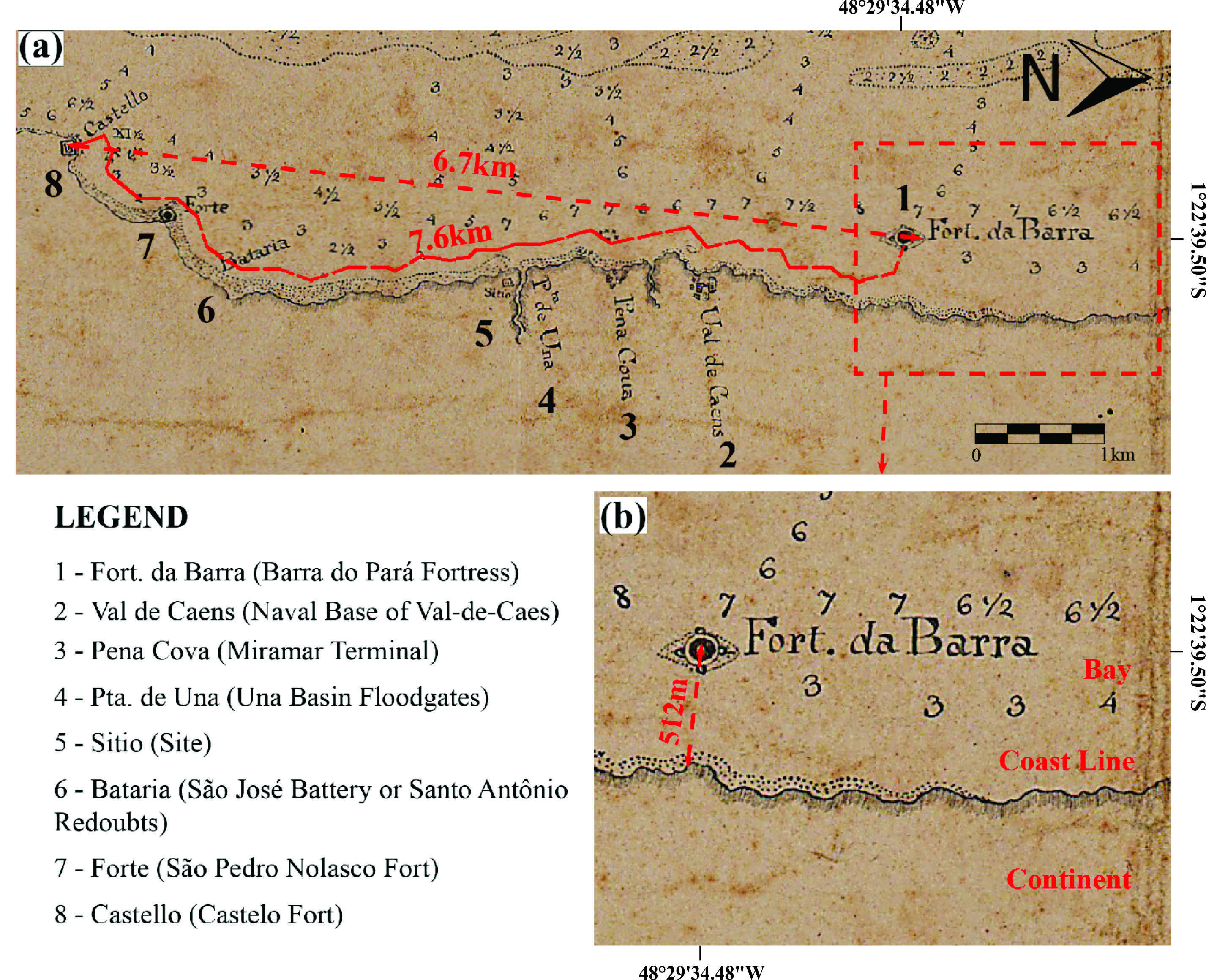
Figure 1. (a) Clipping of the “Mapa da Barra do Pará” from 1793 in which can be observed the location of the Barra do Pará Fortress after the Val de Caens site where there was a battery; (b) Detail of the map in which the circular shape of the Barra do Pará Fortress stands out (about 512m from the margin). Source: Arquivo Nacional/BR (modified).
The “Planta Hydrographica do Porto do Pará” from 1889 (Figure 2) the nomenclature used for the land located just ahead of the fortress called “Pontal da Fortaleza” is observed. In addition, it is verified that the measurement of the distance from Barra do Pará Fortress to the origin nucleus of the city, identified by the signage of Sé Church as “Sé” and the “Largo do Palácio”, near of the Castelo Fort, is compatible with the measures described in the reports of Baena (1839). The fortress on this map is located about 512 m from the margin (Figure 2b).

Figure 2.(a) “Planta Hydrographica do Porto do Pará” of 1889 with approximate measurement between the Barra do Pará Fortress and Castelo Fort (about 8.5 km). (b) In detail can see the Barra do Pará Fortress (Fortaleza da Barra) near the “Pontal da Fortaleza” (about 509 m from the margin). (Source: Arquivo Nacional/BR.
Considering these references, LANDSAT satellite images from 2005 to 2019 were evaluated, observing possible reminiscences that denoted some physical trace in the contemporaneity of the location of the Barra do Pará Fortress. The images chosen were those in the low tide that allowed a better visualization of the study area.
The image obtained by remote sensing (2020) is consistent with the possible location of the fortress at the height of the Val-de-Cães neighborhood (Figure 3a). The increase of this point presents the beacon and an elongated sandbar (Figure 3c). In the digital base Google Maps, there is a place marking in the bay where a base structure and a beacon with the name “Forte da Ilha da Barra”, possibly referring to the Fortress of Nossa Senhora das Mercês da Barra do Pará or the Barra do Pará Fortress (Figure 3e).
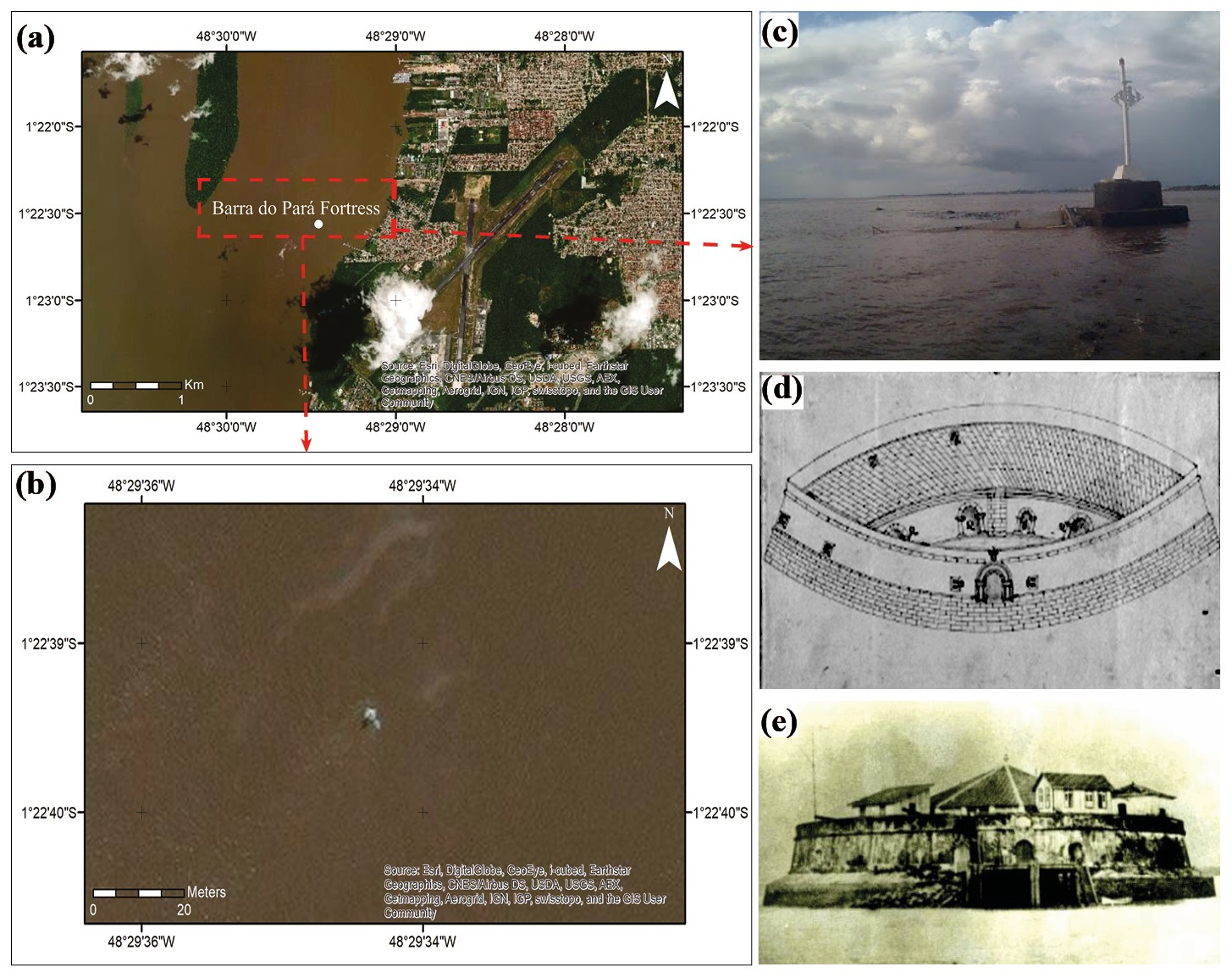
Figure 3. (a) Google 2020 satellite image showing the possible location of the old Fortress of Nossa Senhora das Mercês da Barra do Pará marked as “Forte da Ilha da Barra” on the Google Maps platform; (b) View of the point at which the beacon and a sandbar are observed; (c) Possible location with structure base and beacon; (d) Original perspective drawing of the Barra do Pará Fortress from 1696; (e) Image of de Fortress before the explosion. Sources: (a, b) Google Earth 2020; (c) Photo of Max David, 2016 available on Google Maps; (d) Arquivo Histórico Ultramarino; (e) Coimbra 2002.
In the LANDSAT satellite images captured in the period from 2005 to 2019 despite the different tidal regimes it is observed the existence of the sandbank. The diameter attributed to the Barra do Pará Fortress was measured from the “Planta da Fortaleza da Barra do Pará” of ca. 1696 with reference to the graphic scale of the drawing treated in the AutoCAD program (Figure 4a).
The comparisons established allowed to conclude that there is compatibility between the historical documents of the fortress and the size revealed in the emerged sandbank´s portions observed by the satellite images captured in the low tide (Figure 4).
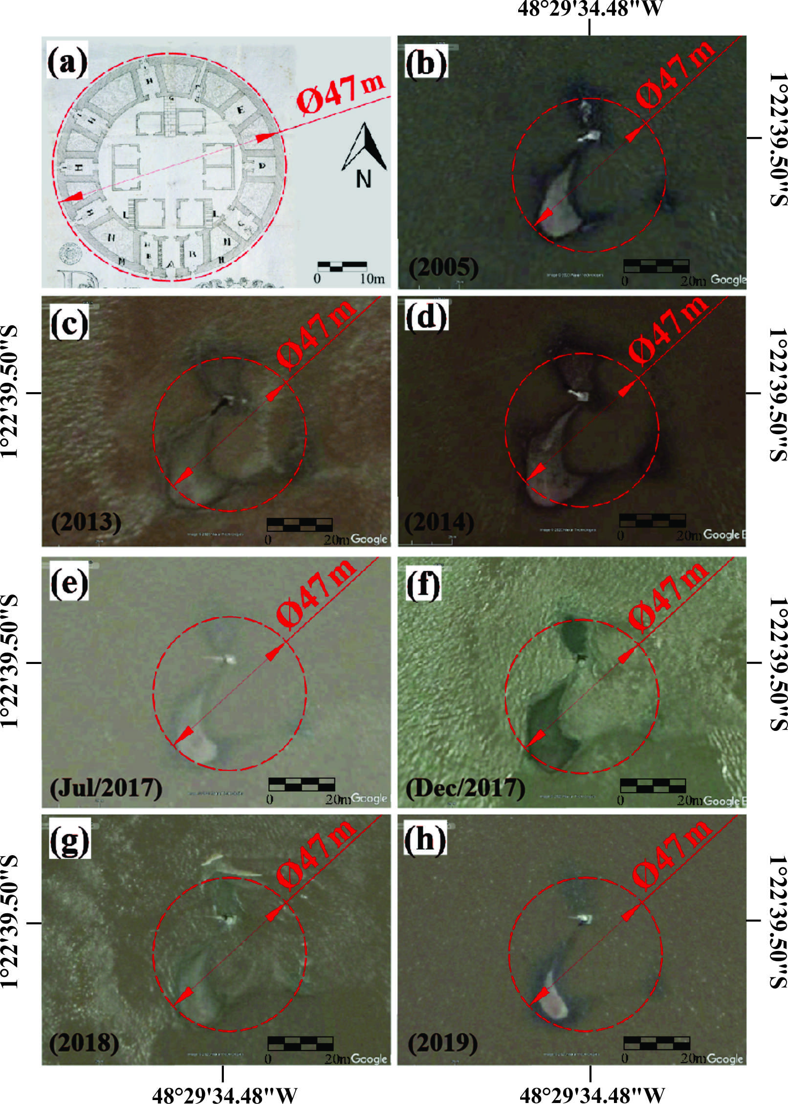
Figure 4. (a) “Planta da Fortaleza da Barra do Pará” from 1696, probably, with an approximate diameter of 47 meters compared with satellite images from 2005 (b), 2013 (c), 2014 (d), July and December 2017 (e, f), 2018 (g) and 2019 (h). Source:(a) Arquivo Histórico Ultramarino; (b, c, d, e, f, g and h): Google Earth, modified.
Superimposing the map of Pará bar (“Mapa da Barra do Pará” from 1793) with the 2020 LANDSAT satellite image, in the form of an overlay, it is possible to notice that very strong hydrodynamic changes had occurred, with many bars appearing and disappearing and some bars even being already forested. This is very frequent in Amazonian river systems.
However, analysis of old allotments displays evidence of current correspondences, such as the site of “Val de Caens” with the current “Naval Base of Val-de-Caes”; the “Pena Cova” site with the “Miramar Terminal” and “Pta. do Una” with the current location of the “Una Basin” floodgates (Figure 5).
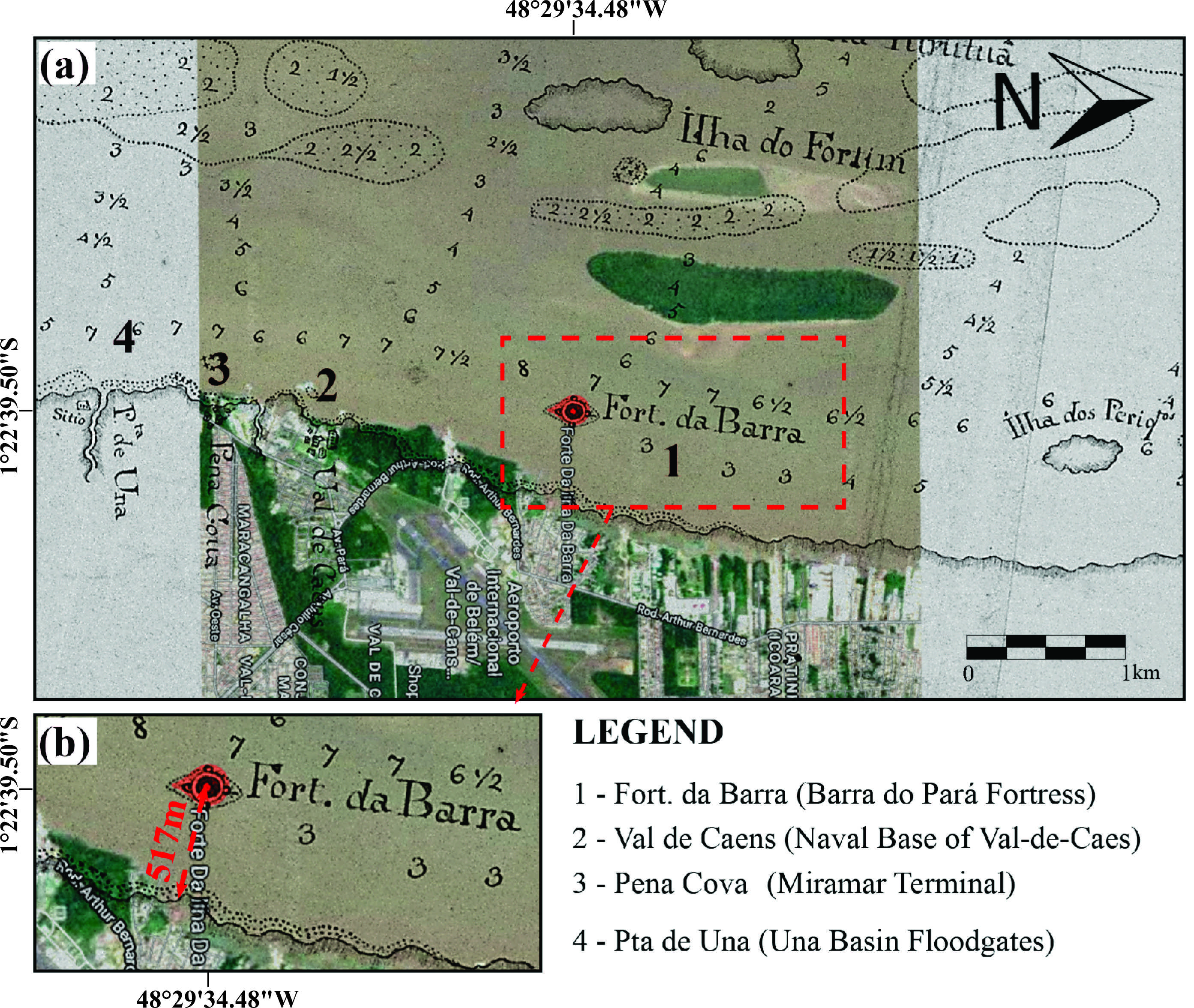
Fig. 5. (a) Clipping of the “Mapa da Barra do Pará” (1793) in overlapped of the satellite image of the area in 2020, in which are identified the Barra do Pará Fortress and another reference points; b) detail of the overlay of the old coastline on the old maps and the current one on the Google Earth image. Source: Arquivo Nacional and Google Earth 2015 (Adapted).
In view of these coincident aspects, it is possible to indicate that this is the location corresponding to the position of the Barra do Pará Fortress at the coordinates 1°22’39.50″S and 48°29’34.48″W, distancing about 517m off the continental portion (Figure 5b), values which correspond to the approximate measurements referenced in the maps of the 1793 and of the 1889.
Although the sedimentary environment at that location presents physiographic characteristics that facilitate the dynamics of the geomorphological elements in the bay, no significant spatial displacements were observed for Barra do Pará Fortress and the coastline in that small portion when comparing historical documents in the last 200 years. Even with intervals in the records used in this work are approximately 100 years, the reference points marked on the historical maps did not register important variations in the distancing of the objects represented graphically, and this disposition was maintained when compared with the most recent satellite images produced through the sensing remote.
This atypical scenario may be the result of anthropic interference with Barra do Pará Fortress in the 16th century, with the construction of solid foundations that may have produced a physical barrier to the predominant flow of the bay. The coast line ahead is parallel to the limit of the main flood channel from inland tide to bay, with a profile of low sedimentary accumulation, whose expressive native vegetation and subsequent human occupation, may have contributed to its low mobility over the period analyzed.
CONCLUSION
The historical iconography and the recent satellite images were useful in the investigation of a disappeared fortified structure Barra do Pará Fortress.
The correspondence between the sites in the 18th century documentation and the current urban terrain occupation and the reference points that followed, maintaining historical relationships associated with the nomenclatures of the past sites help the location of the investigated points.
The research also demonstrated strong transformation of the river/bay dynamics creating new bars and eroding older ones, even that one of the Barra do Pará Fortress, after explosion event.
Acknowledgments
The authors would like to thank Pró-Reitoria de Pesquisa e Pós-Graduação/PROPESP/UFPA, for supporting scholarships (PIBIC/UFPA) for second author; to the CNPQ for a financial grant (305015/2016-8) to the fourth author.
REFERENCES
Azevedo J.C. 1696. Planta da Fortaleza da Barra do Pará. In: Coleção Cartográfica e Iconográfica Manuscrita do Arquivo Histórico Ultramarino. Available in: < >. Acess in: April 09, 2020.
Baena A.L.M. 1839. Ensaio Corografico sobre a Província do Pará. Pará: Typographia de Santos & Menor. No. 15.
Barreto A. 2010. Fortificações do Brasil. Rio de Janeiro: Biblioteca do Exército. 208 p.
Coimbra O. 2002. A Saga dos Primeiros Construtores de Belém. Belém: Imprensa Oficial do Estado, 300 p.
Corrêa I.S. 2005. Aplicação do diagrama de Pejrup na interpretação da sedimentação e da dinâmica do estuário da Baía de Marajó-PA. Pesquisas em Geociências, Porto Alegre, v. 32, n. 2, p. 109-118.
Costa M.L.; Oliveira S.M.B.; Costa G.M.; Choque Fernandez O.J. 2004. Morfologia e química da goethita de pedra de ferro de interface areia-argila em sedimentos da Formação Barreiras, Amazônia Oriental. Geochimica Brasiliense. 18(2): 121-133.
Fau. Laboratório Virtual, ITEC/UFPA. 2015. Fortaleza da Barra explode em 09 de maio de 1947. Available in: <http://fauufpa.org/2015/11/23/fortaleza-da-barra-explode-em-09-de-maio-de-1947/> Acess in September 20, 2019.
Garrido C.M. 1940. Fortificações do Brasil. Separata do Vol. III dos Subsídios para a História Marítima do Brasil. Rio de Janeiro: Imprensa Naval.
Google Earth Pro 2020. V.7.1.2.2041. North of Brazil area 1º22’43.68’’S/48º29’31.2W, elevation 11m. Viewed April 01, 2020. <https://www.google.com/earth/>.
Gregório A.M.S.; Mendes A.C. 2009. Batimetria e sedimentologia da Baía do Guajará, Estado do Pará, Brasil. Amazônia: Ciência e Desenvolvimento, v.5, n.9.
Meira Filho A. 2015. Evolução Histórica de Belém do Grão-Pará: Fundação e História 1616-1823. Organização Márcio Meira. 2ª Ed. Belém: M2P Arquitetura e Engenharia. 580p.
Norat R.C.C.; Costa M.L. 2016 (a). Ilhas e fortes da Baía do Guajará em Belém do Pará, Brasil. Boletim do Museu de Geociências da Amazônia – BOMGEAM. Belém, Pará, p.11 – 14.
Norat R.C.C.; Costa M.L. 2017. A Fortaleza de Santo Antônio de Gurupá, Pará, Brasil. BOMGEAM-Boletim do Museu de Geociências da Amazônia, v.8. http://gmga.com.br/a-fortaleza-de-santo-antonio-de-gurupa-para-brasil/
Norat R.C.C.; Costa M.L. 2018. As fortificações da Amazônia: novas fronteiras e desafios. Revista do Patrimônio Histórico e Artístico Nacional, v.1, p.125 – 143.
Norat R.C.C.; Costa M.L. 2019. Characterization, usage and provenance of building rocks in the Fortress of São José of Macapá (Amazon, Brazil). 19. Engineering Geology, 253: 214-228. https://doi.org/10.1016/j.enggeo.2019.03.022
Norat R.C.C.; Costa, M.L. 2016 (b). Ilhas e fortes da Baía do Guajará: a Fortaleza de Nossa Senhora das Mercês da Barra de Belém do Pará, Brasil. Boletim do Museu de Geociências da Amazônia – BOMGEAM. Belém, Pará, p.13 – 15.
O Liberal. 1947. Desapareceu Para Sempre a Fortaleza da Barra. Jornal O Liberal. 10 maio 1947. Available in: <https://fauufpa.org/2015/11/23/fortaleza-da-barra-explode-em-09-de-maio-de-1947/> Acess in September 20, 2019.
Rossetti D. F. 2000. Influence of low amplitude/high frequency relative sea-level changes in a wave-dominated estuary (Miocene), São Luis Basin, northern Brazil. Sedimentary Geology, Coimbra, n. 133, p. 101–128.
Saraiva A.L.M. 2007. Estudos sedimentológico e geoquímico em sedimentos de fundo na Baía de Guajará-Belém (PA). Dissertação de Mestrado. Programa de Pós-graduação em Geologia e Geoquímica. UFPA. 122p.
Souza Filho P.W.M. 2005. Costa de manguezais de macromaré da Amazônia: cenários morfológicos, mapeamento e quantificação de áreas usando dados de sensores remotos. Brazilian Journal of Geophysics, Rio de Janeiro, v. 23, n. 4, p. 427-435.
Szlafsztein A.C.; Norat R.C.C. Costa M.L. 2018. O Forte São Pedro Nolasco ou Baluarte Nossa Senhora das Mercês em Belém do Pará: uma história em blocos de rochas. BOMGEAM- Boletim do Museu de Geociências da Amazônia, v. 5, n. 2.
Vianna A. 1905. As Fortificações da Amazônia. In: Vianna A. (ed.). Annaes da Bibliotheca Archivo Público do Pará. Belém, Typ. e Encadernação do Instituto Lauro Sodré, Tomo Quatro, p. 227-29.