06 – IMPACTS OF URBAN DEVELOPMENT ON AN OXBOW LAKE IN THE AMAZON REGION: LANDSCAPE AND GEOCHEMICAL EVIDENCE
Ano 07 (2020) – Número 02 Artigos
![]() 10.31419/ISSN.2594-942X.v72020i2a6MLC
10.31419/ISSN.2594-942X.v72020i2a6MLC
Marcondes Lima da COSTA*, Instituto de Geociências-IG, Cidade Universitária Prof. José Silveira Netto, UFPA, Campus Guamá, Rua Augusto Correa 1, Belém-PA-Brasil. E-mail: marcondeslc@gmail.com; mlc@ufpa.br, Pesquisador do CNPq.
Luiz Carlos Farias de CARVALHO, Programa de Pós-Graduação em Geologia, Instituto de Geociências-IG, Cidade Universitária Prof. José Silveira Netto, UFPA, Campus Guamá, Rua Augusto Correa 1, Belém-PA-Brasil. E-mail: luiscfc@yahoo.com.br
Patrícia Freitas PEREIRA, Programa de Pós-Graduação em Geologia, Instituto de Geociências-IG, Cidade Universitária Prof. José Silveira Netto, UFPA, Campus Guamá, Rua Augusto Correa 1, Belém-PA-Brasil. E-mail: patriciafreitasp@yahoo.com.br;
Glayce Jholy da Silva VALENTE, Programa de Pós-Graduação em Geologia, Instituto de Geociências-IG, Cidade Universitária Prof. José Silveira Netto, UFPA, Campus Guamá, Rua Augusto Correa 1, Belém-PA-Brasil. E-mail: glaycej@yahoo.com.br.
*Corresponding author
Observations:
This article was completed in 2012/2013, submitted to a journal, which requested very relevant reviews (three reviewers), which were incorporated, but not published.
So, it was saved for 7 years.
ABSTRACT
Amapá Lake is an abandoned meander of the Acre River, the margins of which are occupied by agricultural settlements, smallholdings, fish farms and dirt roads. This paper discusses the impact of this occupation on the lake area based on field data and physical-chemical and elementary chemical analyses of the lake and river waters. The strong physical changes in the lake landscape have impacted the quality of its water. During the dry season (low water), when the temperature of the water reaches 30-34ºC, there is a proliferation of green algae and in the area affected by fish farms and smallholdings there is an increase in total dissolved solids, electrical conductivity, and transparency, while turbidity and total suspended solids become more concentrated during the flood season. The anthropogenic impact is also indicated by the higher levels of ammonia, chlorides, bromides, and phosphates in the water. However, the concentrations of dissolved metal ions are all consistent with those found in the Acre River, and other muddy water lakes and rivers in the Amazon basin, reflecting the mineralogy of the suspended material. The concentrations of most heavy metals (Pb, Cu, (Zn), Cd and Hg) are below 0.01 mg L-1, while that of Hg (0.006 mg L-1) is above the recommended limits for human consumption. Overall, the results of the study indicate that Amapá Lake is suffering ongoing impacts (physical and chemical) from urban development, which are mitigated by the periodic flooding of the river.
Key words: Urban expansion, Environmental impacts, Waters, Heavy metals.
INTRODUCTION
More than 6500 lakes of different shapes, sizes, and types exist within the Amazon basin. Most of these bodies of water are located along the extensive swampy floodplains of the Amazon and Solimões rivers, where they are connected permanently or seasonally with the river system (Moreira-Turcq et al. 2004), or are formed by the natural blockage of river courses. Many other, smaller (but no less important) lakes are of the oxbow type, and are abundant on the floodplains of the Madeira, Purus, and Juruá rivers and their tributaries (Costa et al. 2005). Another important type is the dendritic ria-lakes, which arise from the intense colmatation of river mouths (Esteves 1998) or through neotectonic activity. In addition to these floodplain formations, many other lakes can be found on higher ground, such as the Carajás (Sifeddine et al. 2001; Costa et al. 2005), Seis Lagos (Bush et al. 2002 and 2004), and Maicuru plateaus. On the upland plains of Roraima, in addition, innumerable small circular or irregularly-shaped bodies of water arise from the relatively superficial location of the water table (Meneses et al. 2007).
Sediments from these lakes has been analyzed for the reconstruction of Amazonian paleoclimates and environments, based on palinological, mineralogical, geochemical, isotopic, and radiocarbon approaches (Absy et al. 1997; Behling et al. 2001; Moreira-Turcq et al. 2004; Costa et al. 2005; Irion et al. 2006), as well as limnological techniques (e.g., Sioli 1984; Carvalho et al. 2001).
In recent years, the growing population density of the Amazon basin has provoked increasing encroachment of the fluvial plains and impacts on its lakes, which represent an important source of freshwater. An example of this process is Amapá Lake on the outskirts of the city of Rio Branco, the capital of the Brazilian state of Acre. Amapá is an oxbow lake formed from a meander of the Acre River, which occasionally feeds into the lake. In order to investigate the impact of the ongoing expansion of the city on the characteristics of this lake, a process that is still incipient, the present study investigated the physical-chemical parameters and chemical composition of the surface waters of the lake, and analyzed alterations to the landscape caused by the recent human occupation.
Most studies of oxbow lakes have focused on their hydrobiological characteristics (Keppeler and Hardy 2002; Izaguirre et al. 2004; Sousa 2007). The recent studies based on an approach similar to that of the present study have focused on oxbow lakes in desert, steppe, mixed forest taiga, and tundra in Poland and Russia (Glinska-Lewczuk, 2009; Sklyarova et al. 2012; Moiseenko et al. 2013), conditions considerably distinct from those of Amapá Lake. While eutrophization is a natural process observed in many lakes (Miranda et al. 2001; Robarts et al. 2005), there is increasing preoccupation worldwide with regard to the effects of urban development on tropical forests, such as that of the Amazon basin, in particular with regard to the acceleration of the eutrophication process.
Amapá Lake is located 8 km from the center of Rio Branco (Figure 1). The lake, which is approximately 3 km long, is still linked seasonally to the Acre River, especially during the major floods, such as those recorded in 1978, 1988, 1997, 2006, 2012 and 2013. In February 2006, the depth of the lake in its central portion reached 10.6 m (it is normally 3–4 m).
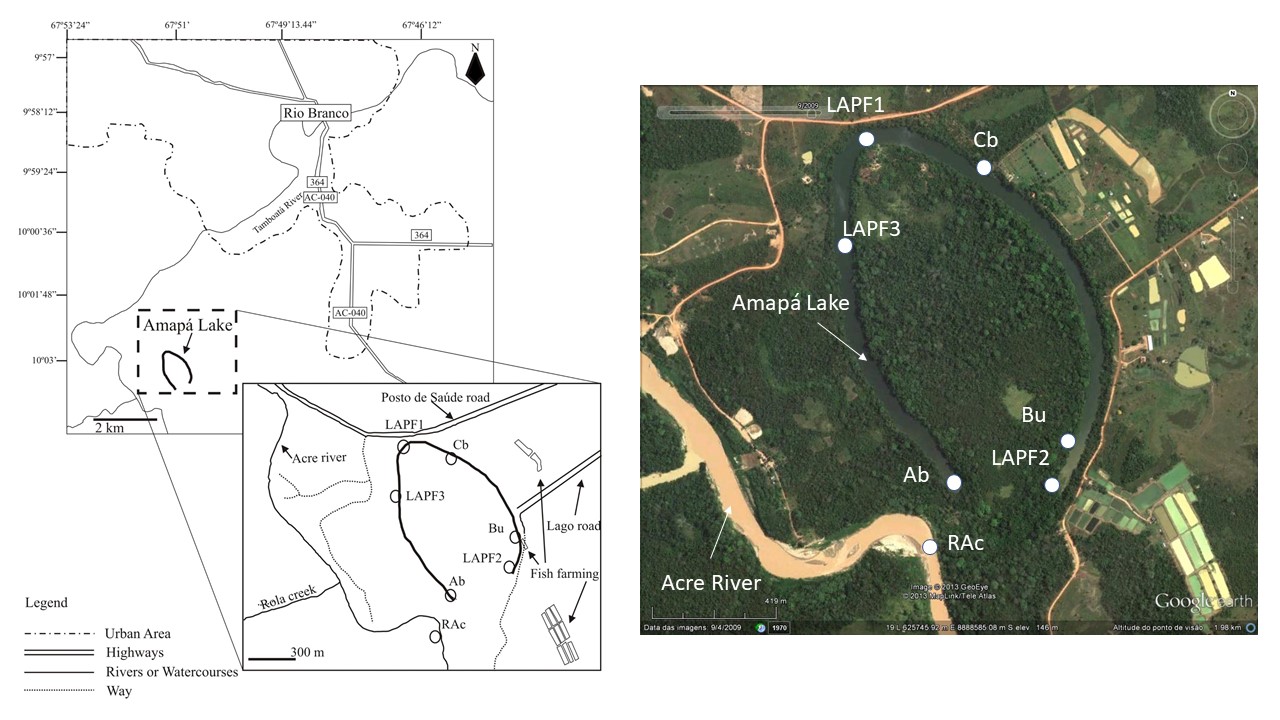
Figure 1. Location of Amapá Lake on the outskirts of the city of Rio Branco, Acre (Brazil) and in the detail the distribution of water sampling stations in the Lake (LAPF1, LAPF2, LAPF3 and the Acre River (RAc).
The climate of the municipality of Rio Branco is equatorial hot and humid, with two well-defined seasons – a dry season between May and October (which peaks between July and September), and a rainy season, between November and April. Annual rainfall is generally 1877–1982 mm, while mean annual temperatures are 24.7–24.9 ºC. The original vegetation found in the area surrounding Amapá Lake was open rainforest with dense tracts of palms on the old floodplain (Acre 2000).
The municipality of Rio Branco encompasses areas of higher ground (terra firme), but also low-lying terrain, representing old or active Holocene floodplain environments. Lake Amapá is on old floodplains, dominated by gleysols and neosols.
MATERIALS AND METHODS
Physical and environmental impacts on the landscape of Amapá Lake were assessed based on the analysis of satellite images and field observations. The analysis of chemical-physical parameters and water chemistry was based on data collected at six stations (Ab, LAPF3, LAPF1, Cb, Bu, LAPF2) distributed within the full length of the lake, and one (RAc) in the Acre River at the western extreme of the oxbow (Figure 1) as a control point. Data were collected during four distinct periods, covering the different aspects of the seasonal variation. Physical-chemical parameters (pH, temperature, dissolved oxygen – DO, electrical conductivity – EC, total dissolved solids – TDS, turbidity, total suspended solids – TSS, and transparency) were measured in loco. Samples of 10 L of water were collected at each station for the measurement of cations, anions, and dissolved metals.
A subsample of 5 L was retrieved from each sample for analysis in the field laboratory, where ammonia, nitrite, phosphate, bromide, and chloride concentrations were determined. The other 5 L was filtered through cellulose ester Millipore-type membranes (porosity ≤0.45 mm) using a portable vacuum pump. The filtered samples were stored in flasks containing three drops of ultra-pure tridistilled nitric acid (HNO3) for conservation. The physical-chemical parameters and anion concentrations of the water samples were determined using a pH-meter-conductivimeter (Metrohm 744, Herisau, Switzerland), and spectrophotometer (DR/2000, Hach Company, USA) at the Evandro Chagas Institute and Applied Mineralogy and Geochemisty Group (GMGA) at the Federal University of Pará, both in Belém, Brazil. Dissolved Al, Fe, Na, K, Mg, Mn, Ti, Ba, Sr, Rb, Li, Pb, Cu, Zn, As, Cd, Hg, Se, Cs, Ce, U, Sn, Sb, B and I concentrations were measured by Inducted Coupled Plasma Mass Spectrometer – ICP-MS (Ultramass 7000, Varian, Sidney, Australia) at Astratom Pesquisas e Análises Ltda, in São Paulo.
RESULTS
Anthropogenic Landscape Changes
The area surrounding Amapá Lake suffered intense anthropogenic transformations beginning in the 1960s, when its native rubber groves became unproductive, and the rubber tappers were relocated to agricultural settlements. In the 1990s, however, the area was gradually occupied by suburban development, including dirt access roads and lanes, smallholdings, and effluent outlets and holiday homes, all of which have provoked extensive deforestation. In the 2000s, a city bypass was built, which crossed the region adjacent to the lake, linking the access roads to the BR-364 highway, and thus accelerating urban development.
The margins of the lake were originally covered by gallery forest, which in the present day has been partially lost, allowing the erosion of lake banks exposed to the heavy local rainfall. Aerial photographs and recent satellite images, most of which are available on Google Earth (between 1969 and 2011), confirm the intense physical impact of the human occupation process on the lacustrine ecosystem (Figure 1), in addition to the acceleration of the natural colmatation caused by the lateral erosion of the lakes margins.
The dirt road that skirts the lake also contributes to the accumulation of suspended material through the provocation of dust clouds, especially during the dry season (Figure 1). Colmatation also results naturally from the input of suspended material from the Acre River, which is linked to the western extreme of the lake, close to station LAPF2, during the high-water period. In 2012, when the Acre River flooded to one of its highest ever levels, the lake obviously received a large volume of water and suspended material, and its margins were partially eroded, while at the same time being silted with fine sediments. In March, 2013, a new major flood on the Acre River once again encroached the lake.
Fish farms established in the principal deforested areas rely on the lake for part of their water supply; an effluent pipe running into Amapá Lake was observed near to an earthen promontory made up of building residues.
Green algae flourished both at the surface and in the deeper strata of the water during the long dry season.
Physical-chemical parameters of the lake water
Temperature – Little variation in the temperature of the water of Amapá Lake was observed among stations or over time, with values of between 28 and 30 ºC generally being recorded (Figure 2A). Greater variation was recorded at LAPF1, which is the station most exposed to sunlight due to its position in the major east-west axis of the lake, from which the vegetation has been partially removed.
pH – The pH values ranged from 6.5 to 9, and were higher during the peak of the dry season (Figure 2B). During this period, the pH of the surface water was around 9, which remained stable down to a depth of 60 cm, but then declined to neutral values at 100 cm. The most abrupt variation was recorded at station LAPF2, where the pH decreased from 8.7 to 6.7 between 60 cm and 80 cm below the surface. The pH values recorded during the rainy season are within the range typically found in other Brazilian floodplain lakes (Carvalho et al. 2001).
During the rainy (flood) season, when the waters of the Acre River (pH = 7) invade Amapá Lake (pH of around 8 to 9), bringing organic (plant) debris and a great deal of suspended material, the pH of the lake waters decreases, reflecting the input of H+ ions. The photosynthetic activity of the algae decreases, resulting in a reduction in the consumption of CO2 that in dry season increases due to the greater penetration of sunlight into the body of water. The resulting layers of algae formed on the surface of the lake remove CO2 from the water and raise its pH.
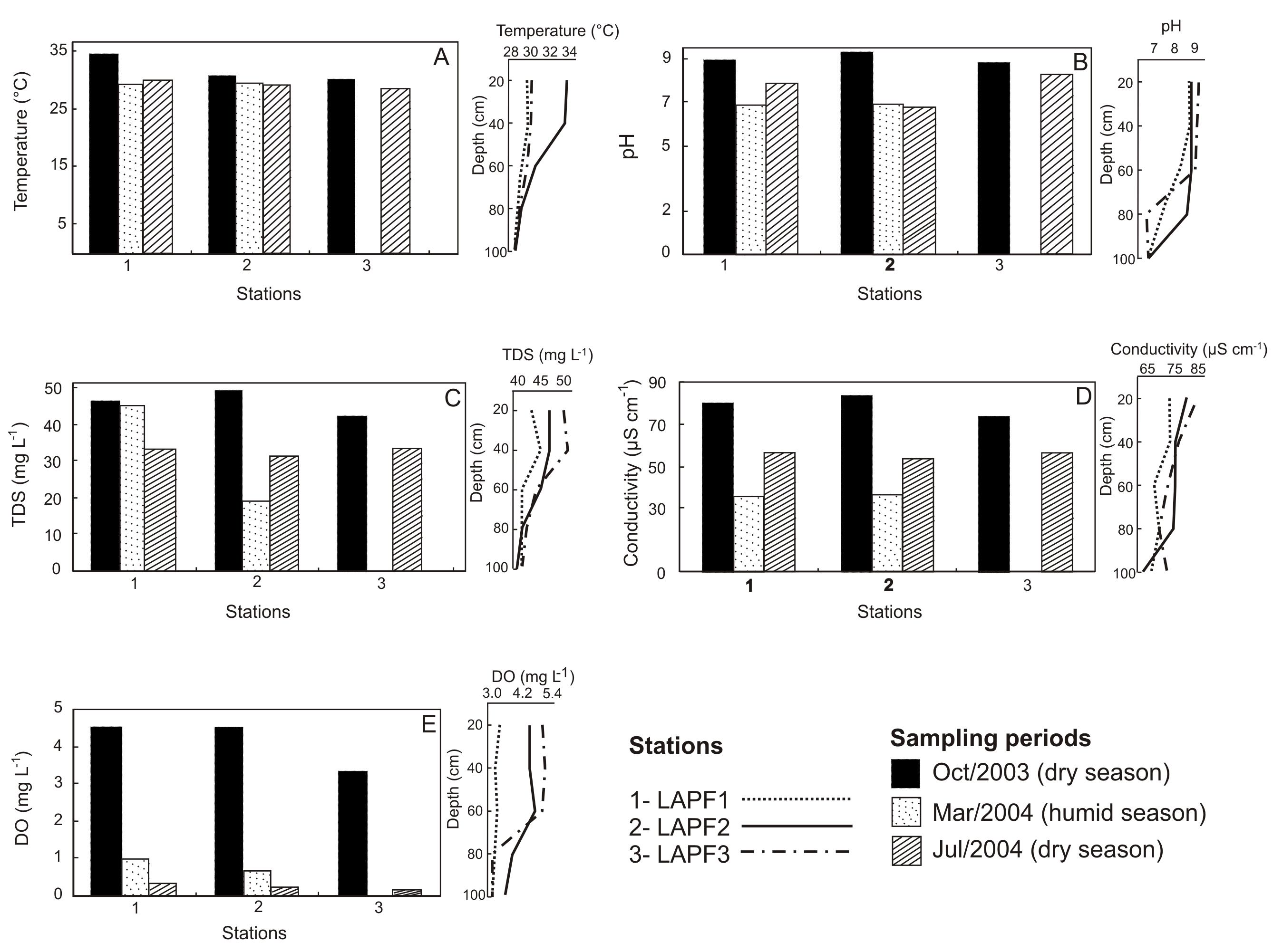
Figure 2. Variation in the physical-chemical parameters of the waters of Amapá Lake. A) Temperature; B) pH; C) TDS; D) Conductivity; E) DO. The values for the surface water are given to the left and those for deep water, to the right.
Total Dissolved Solids (TDS) – Values of 7 to 50 mg L-1 were typically recorded for TDS in Amapá Lake (Figure 2C), increasing during the dry season, to levels higher than those recorded in urban lakes in Roraima (Meneses et al., 2007). During rainfall, the level of the lake rises, diluting these concentrations, in particular when there is an influx of river water. The exactly opposite pattern was observed in rivers in the Qinghai-Tibet region of China (Xu et al., 2010). The greatest variation was observed at depths of between 40 and 60 mg L-1 at station LAPF2 (Figure 2C) near the fish farms.
Electrical Conductivity (EC) – The EC of the waters of Amapá Lake is relatively high (Figure 2 D), reaching up to 83 μS cm-1) over the study period, in a manner similar to TDS, that is, becoming more concentrated during the dry (low water) season, and lower during the rainy season, reaching 55 μS cm-1). Values also decline gradually with increasing depth, decreasing to approximately 70 μS cm-1. These values are comparable to those reported for other Amazonian river basins, such as the Solimões and Purus (Fittkau, 1971; Horbe et al. 2003).
Dissolved Oxygen (DO) – The DO concentrations varied from 3.3 to 5.0 mg L-1, with the highest values being recorded at the peak of the dry season (Figure 2E) at stations LAPF1 and LAPF2, ranging from 4.8 mg L-1at the surface and decreasing further to 3 mg L-1 between 80 and 100 cm due to the reduction in sunlight penetration.
Turbidity, Total Suspended Solids (TSS) and Transparency – Turbidity varied between 20 and 96 NTU, with higher values generally being recorded during the flood period, except at station LAPF2 (Figure 3A), where values were high – 68–88 NTU, close to the fish farms, and the input of solid effluents into the lake and the resuspension of the bottom sediments probably provoked by wind action in the shallow waters and/or the occurrence of effluent discharge. The inflow of the waters of the Acre River, which are more turbid due to the amount of suspended inorganic material, also contributed to the increase in turbidity during the flood season. The TSS concentrations varied from 8 to 60 mg L-1, with the highest values being recorded at station LAPF2 (Figure 3B), correlating clearly with the levels of turbidity. The highest transparency was recorded in the dry season, with values ranging from 96 UC at LAPF1 to 460 UC at LAPF2. Transparency is also related to the hydrological regime of the fluvial-lacustrine system. During the flood period, the quantity of suspended material in the water increases, leading to reduced transparency, in contrast with the pattern observed in the dry season.
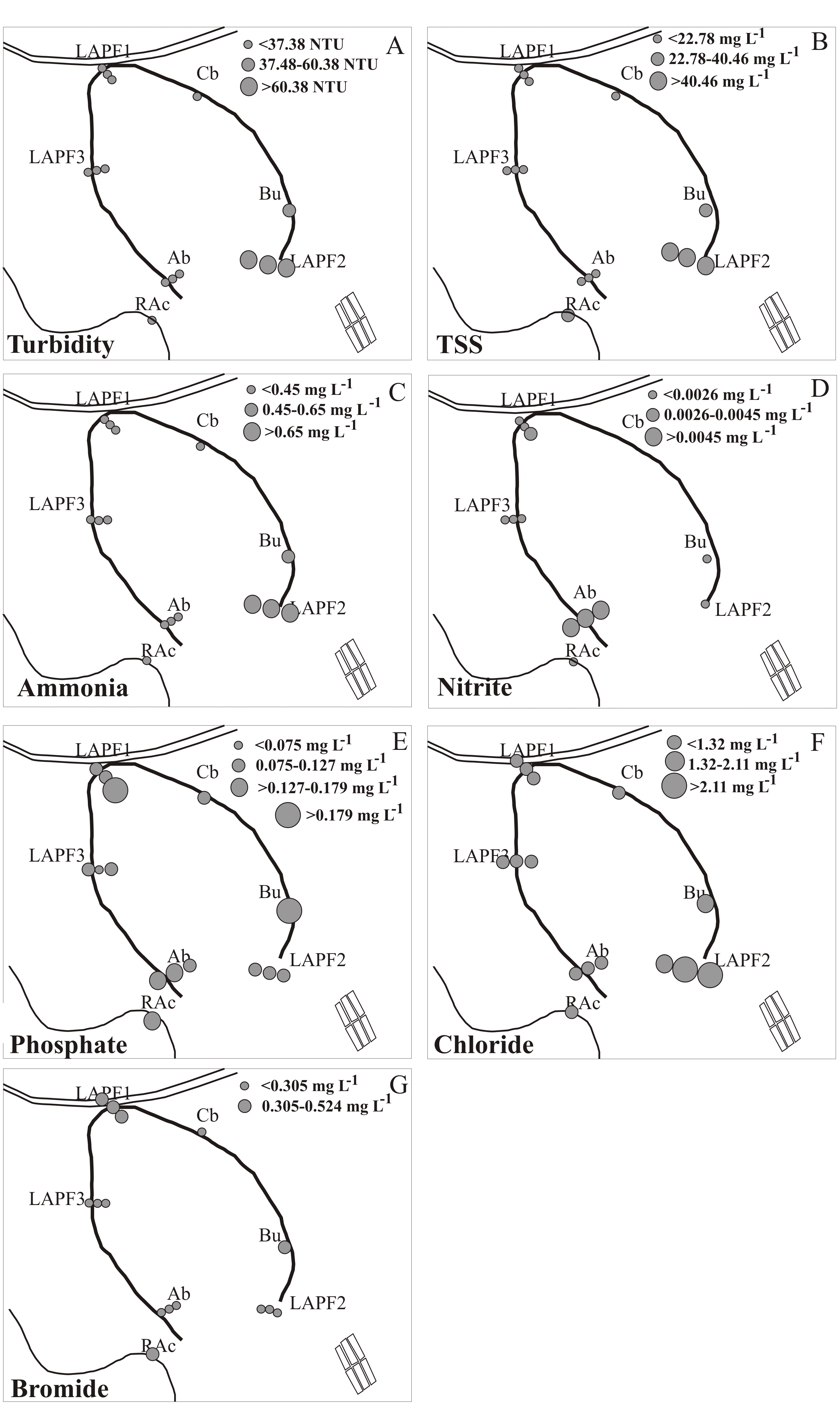
Figure 3. Variations recorded in turbidity, TSS and anion concentrations in the surface water of Amapá Lake (depths of 0-0.1 m) in July, 2005: (A): turbidity; (B): TSS; (C): ammonia; (D): nitrites; (E): phosphates; (F): chlorides; (G): bromides.
Water chemistry
Ammonia – The concentrations recorded in the surface water ranged from 0.19 to 1.00 mg L-1 (Figure 3C and 4A), except for a value of only 0.03 mg L-1 at station LAPF1 (Figure 3C). The highest value (1.00 mg L-1) was detected at LAPF2 (Figure 3C), which reinforces the contribution of fish-farming, or the presence of small-bodied animals in the lake, leading to the presence of excrement and putrefying carcasses, which release organic nitrogen into the water.
Nitrites and Nitrates – The few available data indicate that the periods with the lowest concentrations of ammonia present slightly higher levels of nitrites, varying from 0.001 a 0.006 mg L-1 (Figure 3D), well below the limit established by the Brazilian National Environment Council, CONAMA (1986), for water destined for human use or consumption (1 mg L-1). The nitrite concentration at LAPF2 was very low (0.006 mg L-1), but higher values were recorded at station Ab at the opposite extremity of the lake in relation to the fish farms (Figure 3D). This relatively low value may be related to the more efficient recycling of nitrogen (NO2–) in this area, due to the ongoing ammonia recharge from the source mentioned above.
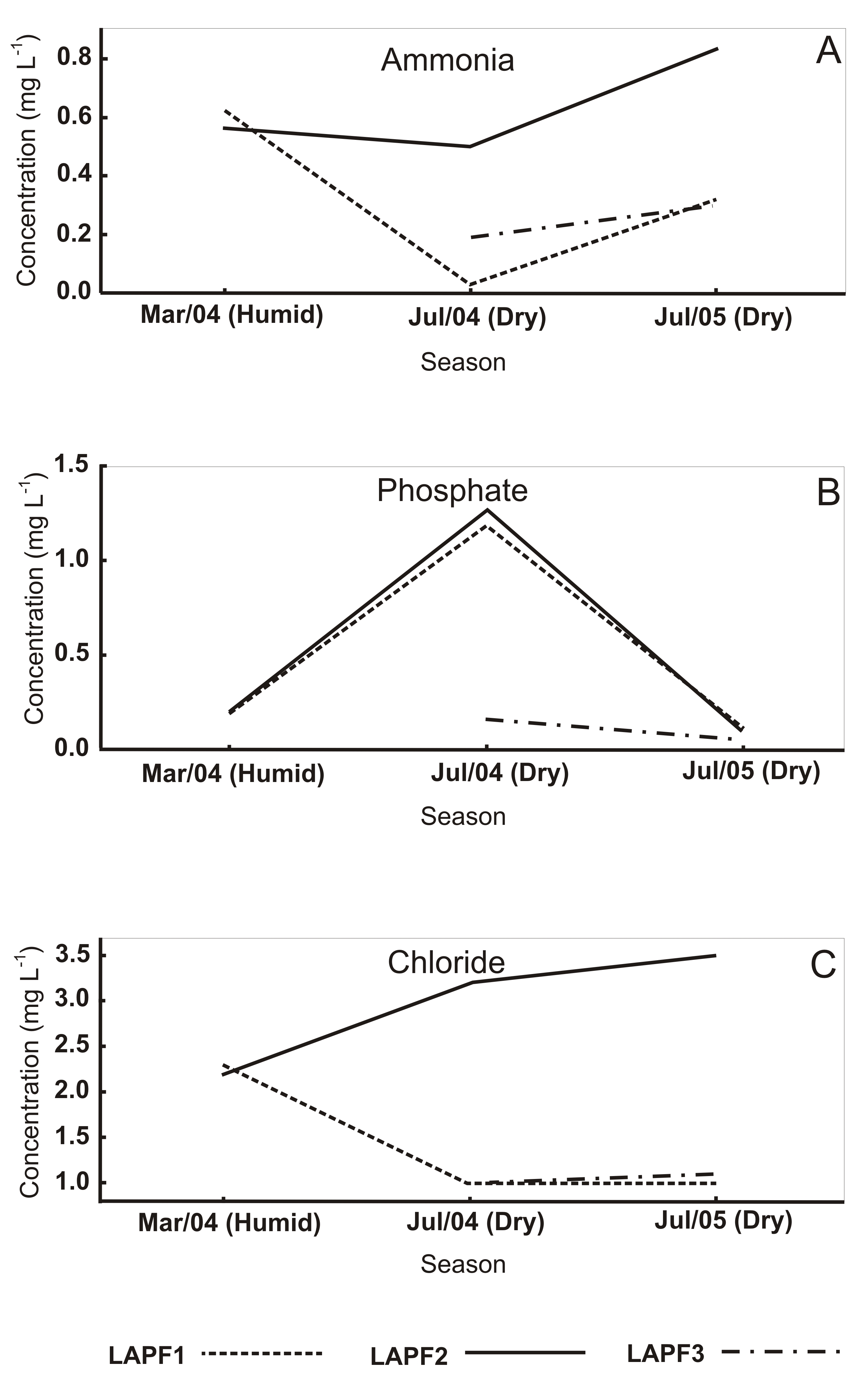
Figure 4. Seasonal and spatial variation in the anion concentration in the surface waters of Amapá Lake: (A) ammonia; (B) phosphates; and (C) chlorides. Values are in mg L-1.
Phosphates – Phosphate concentrations vary considerably, between 0.06 and 1.27 mg L-1 (Figures 3E and 4B). In July, 2005, slightly higher concentrations were recorded at stations LAPF1, Bu, Ab, and RAc (from 0.18 mg L-1 up to 0.26 mg L-1) (Figures 3E). The concentrations recorded are comparable to those registered for total phosphorus in Amazon floodplain lakes (Carvalho et al.2001), and are only slightly higher than the limit recommended by CONAMA (1986) for human use, which is 0.025 mg L-1. The high values recorded in the dry season (July 2004) suggest once again the influence of anthropogenic factors, which contributed to the intense growth of green algae.
Chlorides – Chloride concentrations in the rainy season varied only slightly, from 2.2 to 2.3 mg L-1 (Figures 3F and 4C). During the dry season, the concentrations decreased to 1.0 mg L-1 at stations LAPF1 and LAPF3. At LAPF2, however, the values increased to 3.2–3.5 mg L-1 (Figure 3F). A large rookery is located next to this station, providing an additional source of nutrients in the form of the effluents produced by the breeding birds. Chlorine can also be found as salts in the foods given to fish and cattle in the surrounding farms. The values are comparable to those of mixed and white (muddy) water lakes in Amazonas state (Furch 1984; Horbe et al. 2003) and hundreds of times lower than the limit defined by CONAMA (1986), i.e., 250 mg L-1 of chlorine.
Bromides – Bromide concentrations varied from 0.11 to 1.03 mg L-1 The highest values were recorded at stations LAPF1 and Bu, and in the Acre River (station RAc) (Figure 3G).
Metallic ions dissolved in the water
The highest concentrations (measured only during the flood period) were recorded for Na, Mg, and K (Ca was not determined), followed by Fe, Al, and Mn (Table 1). The values are consistent with those recorded for the Acre River and also ranked in the same order (Figure 5). Sodium concentrations were around 2 mg L-1 at stations LAPF1 and LAPF2 in Amapá Lake as well as in the waters of the Acre River, equivalent to the means recorded in Jacaretinga Lake (Furch 1984), but higher than those recorded in the Solimões and Purus rivers (Horbe et al. 2003) of white (muddy) waters (Table 1 and Figure 5). The levels of Mg in the Lake were also consistent with those recorded in the Acre River, and are comparable to those of the waters of Jacaretinga Lake and the Solimões and Purus rivers (Table 1). The concentrations of K are also of the same order of magnitude as those of Mg recorded in the water of Amapá Lake and Jacaretinga Lake.
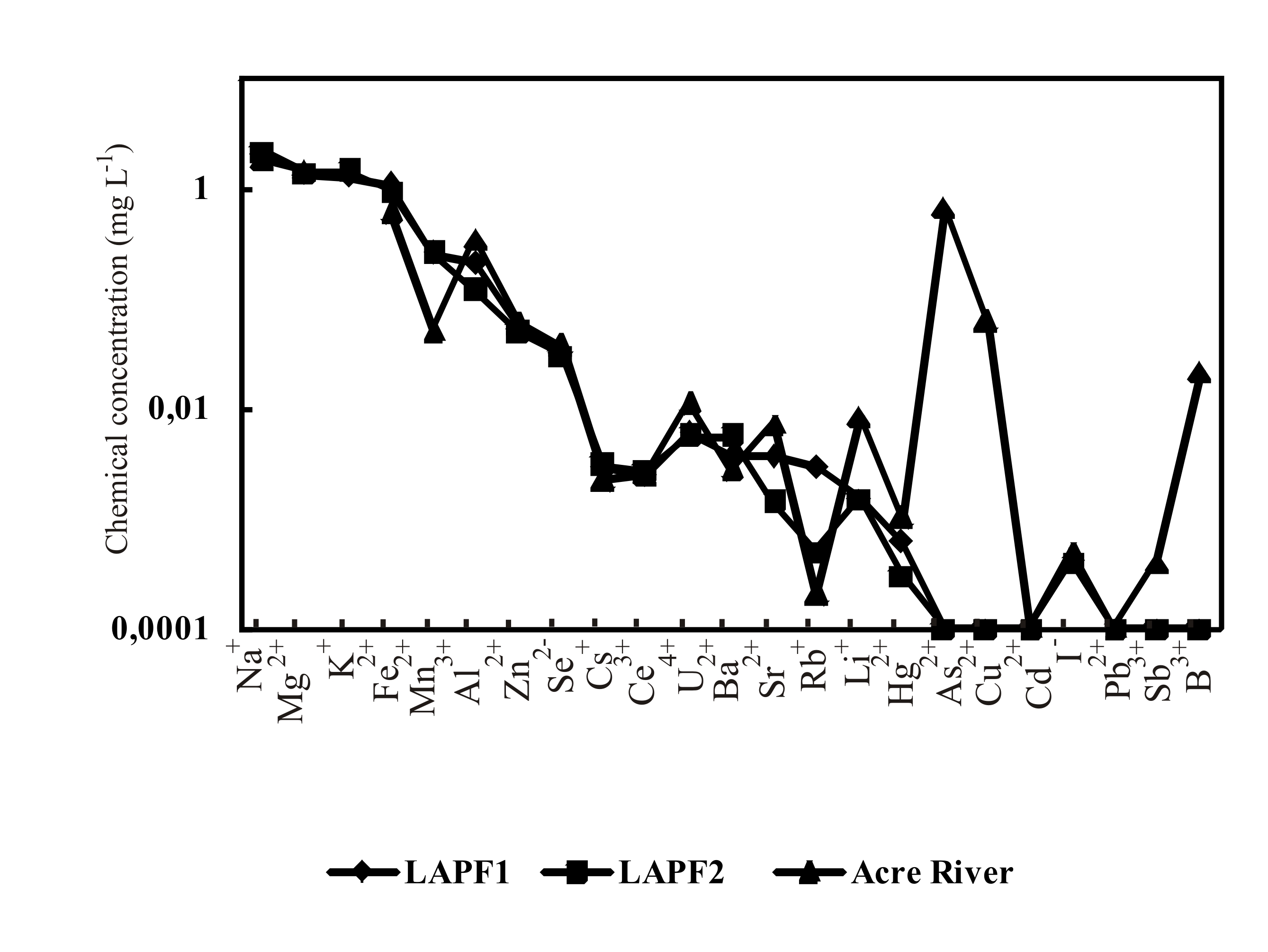
Figure 5. Comparison between the water of lake Amapá and Acre river (station RAc) after the concentration of dissolved ions from major and trace elements.
Table 1 – Content of dissolved chemical elements (cations and anions) measured in the surface water from Amapá Lake and Acre River compared with data from lakes and rivers with muddy water.
| Ions | LAPF1
mg L-1 |
LAPF2
mg L-1 |
Acre River mg L-1 | Acre Rivera
mg L-1 |
Acre Rivera
mg L-1 |
Acre Rivera
mg L-1 |
Jacaretinga
Lake b mg L-1 |
Solimões and
Purus riversc mg L-1 |
CONAMA
mg L-1 |
| Na+ | 2.031 | 2.181 | 1.8421 | 4.73 | 3.52 | 6.91 | 2.5 | 0.86 | – |
| Ca2+ | nd | nd | nd | 11.89 | 6.98 | 18.98 | Nd | Nd | |
| Mg2+ | 1.323 | 1.391 | 1.4729 | 0.84 | 0.48 | 1.37 | 1.4 | 1.12 | – |
| K+ | 1.24 | 1.428 | nd | 2.04 | 1.82 | 2.31 | 1.4 | 0.47 | – |
| Fe2+ | 1.075 | 0.933 | 0.591 | nd | nd | nd | 0.123 | 0.1 | 5 |
| Mn2+ | 0.256 | 0.256 | 0.0499 | nd | nd | nd | 0.003 | < 0.02 | 0.5 |
| Al3+ | 0.207 | 0.116 | 0.3487 | nd | nd | nd | 0.02 | 0.06 | 0.1 |
| Ba2+ | 0.0529 | 0.0483 | 0.058 | nd | nd | nd | 0.0217 | 0.01 | 1 |
| Sr2+ | 0.0322 | 0.03 | 0.0361 | nd | nd | nd | 0.0397 | 9.2 | – |
| Rb+ | 0.0029 | 0.003 | 0.0022 | nd | nd | nd | nd | nd | – |
| Li+ | 0.0024 | 0.0026 | 0.0025 | nd | nd | nd | nd | nd | 2.5 |
| Hg2+ | 0.0059 | 0.0055 | 0.011 | nd | nd | nd | nd | nd | 0.002 |
| As2+ | 0.0036 | 0.0055 | 0.0027 | nd | nd | nd | nd | 0.04 | 0.05 |
| Cu2+ | 0.0036 | 0.0014 | 0.0071 | nd | nd | nd | 0.0016 | nd | 0.5 |
| Cd2+ | 0.0029 | 0.0005 | 0.0002 | nd | nd | nd | nd | nd | 0.01 |
| I– | 0.0015 | 0.0015 | 0.0084 | nd | nd | nd | nd | nd | – |
| Pb2+ | 0.0006 | 0.0003 | 0.001 | nd | nd | nd | nd | 0.16 | 0.05 |
| Zn2+ | < 0.002 | < 0.002 | 0.6689 | nd | nd | nd | 0.0022 | < 0.01 | 5 |
| Se2- | < 0.001 | < 0.001 | 0.0612 | nd | nd | nd | nd | 0.15 | 0.01 |
| Cs+ | < 0.0001 | < 0.0001 | < 0.0001 | nd | nd | nd | nd | nd | – |
| Ce3+ | 0.0004 | 0.0004 | 0.0005 | nd | nd | nd | nd | nd | – |
| U4+ | 0.0001 | 0.0001 | 0.0001 | nd | nd | nd | nd | nd | 0.02 |
| Sn4+ | – | – | – | nd | nd | nd | nd | nd | 2 |
| Sb3+ | < 0.0003 | < 0.0003 | 0.0004 | nd | nd | nd | nd | nd | – |
| B3+ | < 0.001 | < 0.001 | 0.0215 | nd | nd | nd | nd- | 0.01 | 0.75 |
nd: not determined. (-) not indicated. a: Sousa (2007), originally in µM; b: Furch, 1984; c: Horbe et al. (2003) and Costa et al. (2003).
The concentrations of Fe (ca.1.0 mg L-1), twice the level recorded in the Acre River, but much higher than those at Lake Jacaretinga and in the Solimões and Purus rivers (Horbe et al. 2003), but nevertheless within the CONAMA limit (5 mg L–1). The concentrations of dissolved Mn (0.256 mg L-1) are five times higher than those recorded in the Acre River, and 128 times higher than those found in Jacaretinga Lake. In none of these cases, however, do the values exceed those recommended by CONAMA (Table 1). Throughout the state of Acre, black films and small crusts of Mn oxyhydroxides can be observed commonly in young sediments. The concentrations of dissolved aluminum (0.116 to 0.349 mg L-1) are much higher than those recorded for Jacaretinga lake and Solimões and Purus rivers (Furch, 1984; Horbe et al. 2003) and exceed the level recommended by CONAMA (1986), which is 0.1 mg L-1.
The concentrations of Ba, Sr, Rb, and Li (Table 1 and Figure 5) are low and decrease in this order in the water of Amapá Lake and the Acre River. The values recorded for Ba in the Acre River and stations LAPF1 and LAPF2 were approximately five times higher than those recorded in the Solimões and Purus rivers, but still much lower than the limit recommended by CONAMA (1986), i.e., 1 mg L-1.
The concentrations of potentially toxic heavy metals, such as Pb, Cu, Cd, and Hg, are each below 0.01 mg L-1, with Hg and Cu being the most abundant. The Hg values in Amapá Lake are of the order of 0.006 mg L-1 and twice this in the Acre River (Table 1). Mascarenhas et al. (2004) recorded mean concentrations of 0.058 µg g-1 on the upper Acre River, ten times higher than those recorded in Amapá Lake. These metallic ions are probably adsorbed by the clay minerals (smectite and illite), the main mineral components of the suspended inorganic matter. Only the concentrations of Hg (in both Amapá Lake and the Acre River) are above the limit recommended by CONAMA (1986) for water destined for human use.
Cerium, Cs, and U are present at very low levels, and boron and Sb were found in concentrations lower than 0.001 mg L-1, while the concentrations of As and I were slightly higher. While Se was present at less than 0.001 mg L-1 in the lake, the concentration at the Acre River station is 0.06 mg L-1 (Table 1). All these elements, except Se in the Acre River, were found at concentrations lower than those recommended by CONAMA (1986), including As, which was more concentrated in the lake in comparison with the Acre River, as well as iodine (Table 1). The levels of zinc in the lake were relatively low (< 0.002 mg L-1), increasing to 0.67 mg L-1 in the Acre River (Table 1), but even so, much lower than the limit recommended by CONAMA (1986).
DISCUSSION
The area of Amapá Lake has suffered intense impacts caused initially by deforestation followed by the establishment of agricultural settlements, and the gradual encroachment of suburban development, including access roads and lanes, fish farms, smallholdings, holiday homes and effluent outlets, and recently, a city bypass linking the access roads to the BR-364 highway, and thus accelerating urban development. Erosion of the banks and colmatation of the lake basin have increased, and are even more accentuated during the flood season when the river water invades the lake. All the physical impacts of anthropogenic origin have contributed to alterations in the deposition patterns and water parameters of the lake basin. Large quantities of green algae flourish at the surface and in the deeper strata of the water during the long dry season. This proliferation of green algae indicates intense photosynthetic activity, supported by the nutrient input from local human and animal activities, which modifies the pH.
The increase in the availability of oxygen during the dry season accelerates the photosynthetic activity of the phytoplankton in the lake (primarily green algae). However, during the flood season, the penetration of sunlight into the lake decreases, reducing the photosynthetic activity of the algae. The decomposition of submerged organic material and the respiration of aquatic animals contribute to an increase in the consumption of oxygen, reducing the quantity of this gas dissolved in the water. These phenomena indicate the effects of anthropogenic impacts, in particular the discharge of residues and domestic effluents (including those from animal husbandry and fish farms), which transport nutrients into the lake, as indicated by the higher concentrations of ammonia, nitrites, bromides, and phosphates in the lake water. These concentrations indicate that the composition of the water of the lake is distinct from that of the river (Figure 6), and is not balanced effectively by the influx of flood water from the river. By contrast, the mean phosphate concentrations are similar to those of the river, but reach relatively high levels in the vicinity of the areas characterized by long-term human occupation.
Ignoring seasonal variation and sampling stations (Figure 6), the mean values of the physical-chemical parameters and anion concentrations recorded for these two bodies of water (lake and river) are very similar, indicating that the lake water is refreshed during the flood of the Acre River, the main material (water and sediment) pathway to the lake. However, when the different sampling stations are considered and compared, marked local impacts become evident (Figure 2). The highest values of TSS and turbidity reflect the presence of solid and chemical effluents originating from farm activity and indicate that the annual floods are insufficient to compensate for these impacts in the part of the lake furthest from the river, that is, the eastern extreme of the oxbow, where fluvial waters do not circulate.
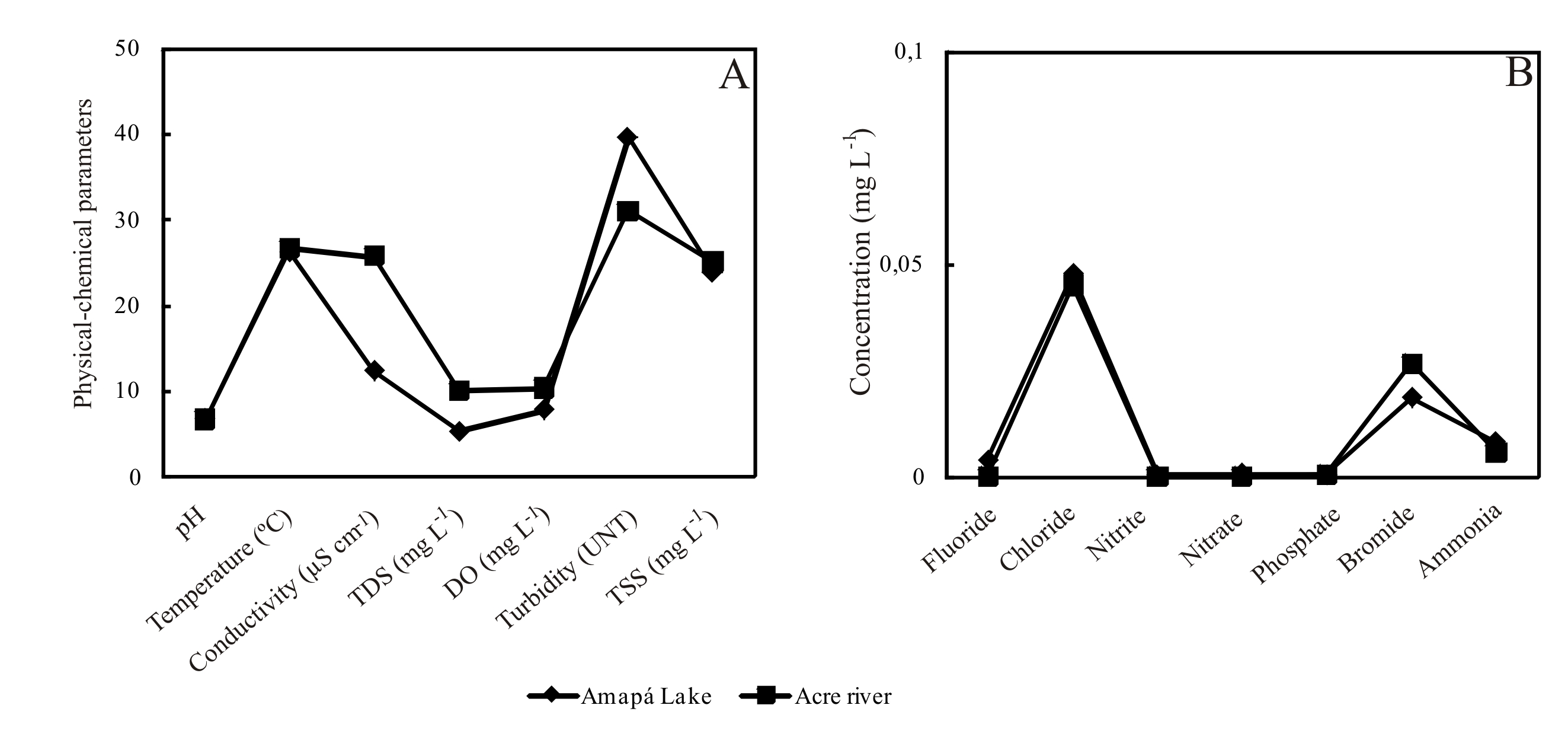
Figure 6. Comparison between the water of Amapá lake and Acre river (station RAc) after the mean physical-chemical parameters and anion concentrations.
In general, the ion concentrations of the chemical elements dissolved in the water of Lake Amapá and the Acre River were similar, except for Zn, which was strongly concentrated in the river water (Figure 5), while Mn, Fe, and Al were relatively diluted. This reflects the influence of the river water on the lake, especially the concentrations of Na, Mg and K (as well as Ba, Sr, Rb, and Li), which reflect the mineralogy of the suspended matter, made up of smectite and illite, which have a marked capacity for ion exchange (Costa et al., 2005). The concentrations of the chemical elements in the Amapá lake water are in general in the same order of magnitude Madeira river water (Horbe et al., 2013). This river display also a white water, similar to Acre river. However, the concentrations of dissolved Fe and Mn, much higher than those recorded in the Acre, Purus or Solimões rivers, indicate a considerable input of iron oxy-hydroxide minerals (which normally contain Al and Mn) into Amapá Lake, probably from the soil of the surrounding area, and in particular from the local dirt roads, which are graded using kaolinite ± goethite ± hematite soils (red-yellow latosols and podzols) imported from nearby quarries. The presence of kaolinite also explains the relatively high concentrations of Al in the lake. A similar pattern was recorded by Moiseenko et al. (2013) in lakes in the mixed forest zone in Russia.
Surprisingly, the concentrations of Hg are lower than those found in the Acre River, while those of As, Cu, Cd and I, despite being relatively low (and less than those recommended by CONAMA, 1986) are higher than those recorded in the Acre River. The even lower values recorded for Pb, Zn, Se and Sb, well below those found in the Acre, indicate the absence of a human source, such as phosphate fertilizers, or they may have been adsorbed into the clay minerals and organic material. The slightly higher concentrations of the heavy metals As, Cu, and Cd, in contrast with Pb, Zn, Se and Sb, indicate the small-scale application of fertilizers (Jiao et al., 2012), insecticides and/or pesticides (Moiseenko et al., 2013). Even so, with the exception of Hg, the concentrations of ions recorded in the present study (Table 4, Figure 7) were well within the public health standards established by CONAMA (1986). High levels of Hg were also found in the Acre River, and have also been recorded in a number of other rivers in the state of Acre (Costa et al. 2009). No data on Hg concentrations were presented in the recent studies of the chemistry of lake water in Russia and China (Xu et al., 2010; Sklyarova, 2012; Moiseenko et al., 2013). Chemically, the results were quite distinct from those obtained from Amapá Lake, probably because they are located in complete different climatic and geological contexts.
CONCLUSIONS
The deforestation and construction of unpaved access roads and an urban bypass, as well as the establishment of smallholdings and fish farms, has contributed to the ongoing modification of the original landscape of Amapá Lake and accelerated its colmatation. The proliferation of green algae reflects the input of domestic effluents and other residues. These anthropogenic impacts are reflected in the changing physical-chemical parameters of the lake’s water.
The relatively high temperatures and the absence of any marked thermal stratification of the lake waters, reinforce the effects of the loss of forest cover, and favor eutrophization. The marked increase in pH related to the photosynthetic activity of the green algae and the higher values of TDS, EC, turbidity, and TSS also reflect the input from the fish farms and smallholdings.
The comparison of the chemistry of the lake water with that of the river also indicates some level of anthropogenic impact from domestic effluents and other residues, with phosphate concentrations exceeding the standards recommended for human consumption.
The concentrations of Na, Mg, and K (more abundant) and Ba, Sr, Rb and Li (less abundant) in Lake Amapá confirm the strong link between the lake and the river water. The higher concentrations of Fe, Al, and Mn indicate the possible influence of the local dirt roads, which are graded with sandy-clayey aggregates and iron oxy-hydroxides. The concentrations of Al are higher than recommended for human consumption. The concentrations of Hg, As, Pb, and Cd indicate that Lake Amapá is being affected by man-made substances, such as insecticide, pesticides, and fertilizers, discharged directly or indirectly into the waters of the lake. Overall, then, the evidence indicates that anthropogenic impacts increase during the low water period, when the connection with the river is lost.
Acknowledgements
We are grateful to the Brazilian Council for Research and Development – CNPq – for financial support (grants: 304519/2009-0, 471109/2003-7, 471949/2006-0, 476645/2001-8) and the Instituto Evandro Chagas for providing laboratory facilities. To the three anonymous reviewers who made excellent notes and suggestions, which were incorporated into the manuscript.
REFERENCES
Absy, M.L.; Prance G.T.; Servente, M.; Miranda, I.S. 1997. Registros Palinológicos em Sedimentos do Holoceno e Vegetação Anual de Roraima. In: Ferreira, E.J.G.; Castellón, E.G. (Orgs.). Homem Ambiente e Ecologia no estado de Roraima. Instituto Nacional de Pesquisas da Amazônia, Manaus, Amazonas. p.462-479.
Acre. 2000. Governo do Estado. Programa estadual de zoneamento ecológico-econômico do Estado do Acre. Zoneamento ecológico-econômico: Recursos Naturais e Meio Ambiente. Documento final. Rio Branco: SECTMA, v. I.
Almeida, J.S. 2000. Influência do Regime Hidrológico sobre algumas Variáveis Limnológicas em um Lago da Planície de Inundação do Rio Acre (Lago Amapá, Acre, Brasil). Dissertação de Mestrado, Universidade Federal do Acre, Rio Branco, Acre. 150p.
Behling, H.; Costa, M.L. 2000. Holocene environmental changes from the rio Curuá record in the Caxiuanã region, eastern Amazon basin. Quaternary Research, 53: 369-377.
Behling, H.; Costa, M.L. 2001. Holocene vegetational and coastal environmental changes from the Lago Crispim record in northeastern Pará State, eastern Amazonia. Review of Palaeobotany and Palynology, 114: 145-155.
Behling, H.; Keim, G.; Irion, G.; Junk, W.; Melo, J.N. 2001. Holocene environmental changes in the Central Amazon Basin inferred from Lago Calado. Palaeogeography, Palaeoclimatology, Palaeoecology, 173: 87-101.
Bush, M.B.; Miller, M.C.; De Oliveira, P.E.; Colinvaux, P.A. 2002. Orbital forcing signal in sediments of two Amazonian lakes. Journal of Paleolinmology, 27: 341-352.
Bush, M.B.; De Oliveira, P.E.; Colinvaux, P.A.; Miller, M.C.; Moreno, J.E. 2004. Amazonian paleoecological histories: one hill, three watersheds. Palaeogeography, Palaeoclimatology, Palaeoecology, 214:359-393.
Carvalho, P.; Bini, L.M.; Thomaz, S.M.; Oliveira, L.G.; Robertson, B.; Tavechio, W.L.G.; Darwisch, A.J. 2001. Comparative limnology of South American floodplain lakes and lagoons. Acta Scientiarum, 23: 265-173.
CONAMA, 1986. Resolução Conama nº. 20 de 18 de junho de 1986, (http//www.ambientec.com). Acesso em 16/03/2006.
Cordeiro, R.C.; Turcq, B.; Suguio, K.; Ribeiro, C.V.; Silva, A.O.; Siffedine, A.; Martin, L. 1997. Holocene environmental changes in Carajás region (Pará, Brazil) recorded by Lacustrine Deposits. Verh. Int. Verein. Limnol, 26: 814-817.
Costa, M.L.; do Carmo, M.S.; Behling, H. 2005. Mineralogia e Geoquímica de Sedimentos Lacustres com substrato laterítico na Amazônia Brasileira. Revista Brasileira de Geociências, 35: 165-176.
Costa, M.L.; Almeida, H. D. F; Rego, J.A.R. 2009. Cultivando praias e barrancos – nordestinos feitos seringueiros, ocupam a Amazônia do Acre. Gráfica Alves, Belém. 230p.
Cunha-Santino, M.B.; Bianchini-Junior, I. 2002. Humic substance mineralization in a tropical oxbow lake (São Paulo, Brazil). Hydrobiologia, 468: 33-43.
Esteves, F.A. 1998. Fundamentos de Limnologia. Editora Interciência/FINEP, Rio de Janeiro, 602pp.
Fittkau, E.J. 1971. Ökologische Gliederung des Amazonasgebietes auf geochemischer Grundlage. Münster. Forsch. Geol. Palaönt., H20/21. In: Esteves, F.A. Fundamentos de Limnologia. Editora Interciência/FINEP, Rio de Janeiro, p.35-50.
Furch, K. 1984. Water chemistry of the Amazon: the distribution of chemical among freshwaters. In: Sioli H. (Ed.). The Amazon – Limnology and Landscape ecology of a mighty tropical river and its basin. v. 56. Dr. W. Junk Publisheres, Dordrecht, The Netherlands. p.167-199
Glinska-Lewczuk, K. 2009. Water quality dynamics of oxbow lakes in young glacial landscape of NE Poland in relation to their hydrological connectivity. ecological engineering, 35: 25–37.
Horbe, A.M.C.; Santos, A.G.S.; Miranda A.S.; Oliveira. L.G.S. 2003. Geoquímica das Águas de alguns Rios da Amazônia Ocidental. v.9, p. 311-312. In: SBGQ, Congresso Brasileiro de Geoquímica. Anais. Belém, Pará.
Horbe, A. M. C.; Queiroz, M.M.A., Moura, C.A.V., Toro, M.A.G. 2013. Geoquímica das águas do médio e baixo rio Madeira e seus principais tributários – Amazonas – Brasil. VOL. 43(4) 2013: 489 – 504. http://dx.doi.org/10.1590/S0044-59672013000400011.
Irion, G.; Bus, M.B.; Nunes de Mello, J.A.; Stüben, D.; Neumann, T.; Müller, G.; Morais, J.O.; Junk, J.W. 2006. A multiproxy palaeoecological record of Holocene lake sediments from the Rio Tapajós Eastern Amazonia. Palaeogeography, Palaeoclimatology, Palaeoecology, 240: 523-535.
Izaguirre, I.; O’Farrell I.; Unrein, F.; Sinistro, R.; Afonso, M. S.; Tell, G. 2004. Algal assemblages across a wetland, from a shallow lake to relictual oxbow lakes (Lower Paraná River, South America). Hydrobiologia, 511: 25-36.
Jiao, W; Chen, W.; Chang, A.C.; Page, A.L. 2012. Environmental risks of trace elements associated with long-term phosphate fertilizers applications: A review. Environmental Pollution, 168: 44-53.
Keppeler, E.C. 2003. Comparative study of the zooplankton composition of two lacustrine ecosystems in Southwestern Amazonia. Acta Scientiarum. Biological Sciences, 25: 467-477.
Keppeler, E.C.; Hardy, E.R. 2002. Estimativa do tamanho das fêmeas com ovos de Moina minuta Hansen, 1899 (Cladocera, Crustácea) no lago Amapá, Rio Branco, Estado do Acre, Brasil. Acta Scientiarum, 24: 321-328.
Latrubesse, E.M.; Nelson, B.W. 2001. Evidence for Late Quaternary Aeolian Activity in the Roraima-Guyana Region. Catena, 43: 63-80.
Mascarenhas, A.F.S.; Brabo, E.S.; Silva, A.P.; Fayal, K.F.; Jesus, I.M.; Santos, E.C.O. 2004. Avaliação da concentração de mercúrio em sedimentos e material particulado no rio Acre, estado do Acre, Brasil. Acta Amazonica, 34: 61-68.
Meneses, M.E.N.S.; Costa, M.L.; Costa, J.A.V. 2007. Os lagos do lavrado de Boa Vista – Roraima: fisiografia, físico-química das águas, mineralogia e química dos sedimentos. Revisa Brasileira de Geociências, 37: 478-489.
Miranda, L.E.; Hargreaves, J.A.; Raborn, S.W. 2001. Predicting and managing risk of unsuitable dissolved oxygen in a eutrophic lake. Hydrobiologia, 457: 177-185.
Moiseenko, T.I.; Skjelkvåle, B.L.; Gashkina, N.A.; Shalabodov, A.D.; Khoroshavin, V.Yu. 2013. Water chemistry in small lakes along a transect from boreal to arid ecoregions in European Russia: Effects of air pollution and climate change. Applied Geochemistry, 28: 69-79.
Moreira-Turcq, P.; Jouanneau, J.M.; Turcq, B.; Seyler, P.; Weber, O.; Guyot, J.L. 2004. Carbon sedimentation at Lago Grande de Curuai, a floodplain lake in the low Amazon region: insights into sedimentation rates. Palaeogeography, Palaeoclimatology, Palaeoecology, 214: 27-40.
Penczak, T.; Galicka, W.; Glowacki, L.; Koszalinski, H.; Kruk, A.; Zieba, G.; Kostrzewa, J.; Marszal, L. 2004. Fish assemblage changes relative to environmental factors and time in the Warta River, Poland, and its oxbow lakes. Journal of Fish Biology, 64: 483-501.
Robarts, R.D.; Waiser, M.J.; Arts, M.T.; Evans, M.S. 2005. Seasonal and diel changes of dissolved oxygen in a hypertrophic prairie lake. Lakes & Reservoirs: Research and Management, 10: 167-177.
Sifeddine A.; Martin L.; Turcq B.; Volkmer Ribeiro C.; Soubiés F.; Campello R.C.; Suguio, K. 2001. Variations of the Amazonian rainforest environment: a sedimentological record covering 30,000 years. Palaeogeography, Palaeoclimatology, Palaeoecology, 168: 221-235.
Sifeddine, A.; Wirrmann, D.; Albuquerque, A.L.S.; Turcq, B.; Cordeiro, R.C.; Gurgel, M.H.C.; Abrão, J.J. 2004. Bulk composition of sedimentary organic matter used in palaeoenvironmental reconstructions: examples from the tropical belt of South America and Africa. Palaeogeography, Palaeoclimatology, Palaeoecology, 214: 41-53.
Simões Filho, F.; Turcq, B.; Carneiro Filho, A.; Souza, A.G. 1997. Registros sedimentares de lagos e brejos dos campos de Roraima: Implicações paleoambientais ao longo do Holoceno. In: Barbosa, R.I.; Fereira, E.J.G.; Castellon, E.G. (Orgs.) Homem, Ambiente e Ecologia no estado de Roraima. Instituto Nacional de Pesquisas da Amazônia, Manaus, Amazonas, p.295-302.
Sioli, H. 1984. The Amazon and its main affluents: Hydrology, morphology of the rivers courses, and river types. In. Sioli, H. (ed.). The Amazon-Limnology and landscape ecology of a mighty tropical river and its basin. Netherlands, Junk Publishers, p.127-166.
Sklyarova, O.A.; Sklyarov, E.V.; Menshagin, Yu.V. 2012. Concentration of trace elements in small lakes of the Ingoda basin (Chita Region, Russia). Russian Geology and Geophysics, 53: 1324–1334.
Sousa, E.S. 2007. Dinâmica do carbono dissolvido no rio Acre: variações sazonais e espaciais. Dissertação de Mestrado, Programa de Pós-Graduação em Ciências Ambientais, Instituto de Geociências/ Universidade Federal do Pará/MPEG, Belém, Pará. 91p.
Turcq, B.; Albuquerque, A.L.S.; Cordeiro, R.C.; Sifeddine, A.; Simões Filho, F.F.L.; Souza, A.G.; Abrão, J.J.; Oliveira, F.B.L.; Silva, A.O.; Capitâneo, J. 2002. Accumulation of organic carbon in five Brazilian lakes during the Holocene. Sedimentary Geology, 148: 319-342.
Xu, H.; Hou, Z.; An, Z.; Liu, X.; Dong, J. 2010. Major ion chemistry of waters in Lake Qinghai catchments, NE Qinghai-Tibet plateau, China. Quaternary International, 212: 35-43.