08 – ENVIRONMENTAL DISASTER IN MINAS DO CAMAQUÃ, RIO GRANDE DO SUL, BRAZIL: A REVIEW
Ano 06 (2019) – Número 03 Artigos
![]() 10.31419/ISSN.2594-942X.v62019i3a8CGR
10.31419/ISSN.2594-942X.v62019i3a8CGR
Claudete Gindri Ramosa*,
Marcondes Lima da Costab
a Universidad de la Costa, Department of Civil and Environmental Engineering. Calle 58 #55 – 66, Barranquilla, Colombia.
b Federal University of Pará (UFPA), Institute of Geosciences, R. Augusto Correa, 1, Guamá, Belém, Pará, CEP: 66075-110, Brazil.
*Corresponding author: e-mail: claudeterms@gmail.com
ABSTRACT
This paper presents a review of the literature on historical and environmental aspects of the copper mining (Cu) tailings dam disruption of the Brazilian Copper Company (CBC) in Minas do Camaquã in the state of Rio Grande do Sul, Brazil. A Cu mine was explored for over 100 years between 1865 and 1996. The reservoir, which received the tailings from the Cu and Au exploration, had an area of about 52 ha. In 1981, there was a 120 mm downpour in approximately 1 h. One of the causes of the incident was insufficient drainage for the high volume of precipitation. A portion of the north dam structure gave way and the tailings reached the João Dias stream bed, which passes near the reservoir. Some research has shown that there are still traces of the material in the Camaquã sandbanks. It is estimated that 60% of the tailings were spread over 116 ha of Minas do Camaquã. The residents of the region lived above the dam and did not suffer from the waste spill, as happened with the Mariana and Brumadinho disasters in Minas Gerais. In Rio Grande do Sul the negative impacts were social and environmental. In the following years the dam was expanded until the end of the exploration in 1996. The reservoir still remains with sedimented tailings and an area of 150 ha of barren landscape being recovered. Studies in the area conducted by the Federal University of Pelotas seek to map the points hit by the residues and to develop a simulation model of disruption of similar structures, to create an instrument that could guide in alert situations, by drawing maps of risk areas and points should be evacuated at similar events.
Keywords: Tailings Dam, Copper, Gold, Environmental Disaster.
RESUMO
Este trabalho apresenta uma revisão da literatura sobre aspectos históricos e ambientais do rompimento de barragem de rejeitos da mineração de cobre (Cu) da Companhia Brasileira do Cobre (CBC), em Minas do Camaquã, no estado do Rio Grande do Sul, Brasil. Uma jazida de Cu foi explorada por mais de 100 anos, entre 1865 e 1996, mas com interrupções. O reservatório, que recebia os rejeitos da exploração de Cu e Au, possuía uma área de cerca de 52 ha. Em 1981, aconteceu uma chuva torrencial de 120 mm em aproximadamente 1 h. Umas das causas do incidente foi a incapacidade do vale para escoar o elevado volume dessa precipitação. Uma parte da estrutura da barragem norte cedeu e os rejeitos alcançaram o leito do arroio João Dias, que passa próximo do reservatório. Algumas pesquisas evidenciaram que ainda há vestígios do material em bancos de areia do Rio Camaquã. Estima-se que 60 % dos rejeitos foram espalhados por 116 ha de Minas do Camaquã. Os moradores da região habitavam acima da barragem e não sofreram com o derramamento dos resíduos, como aconteceu com os desastres de Mariana e Brumadinho, em Minas Gerais, recentemente. No Rio Grande do Sul os impactos negativos foram sociais e ambientais. Nos anos seguintes a barragem foi ampliada, até o final da exploração, em 1996. O reservatório ainda permanece com os rejeitos sedimentados e uma área de 150 ha de paisagem estéril sendo recuperada. Os estudos na área realizados pela Universidade Federal de Pelotas tentaram mapear os pontos atingidos pelos resíduos e desenvolver um modelo de simulação de rompimento de estruturas semelhantes, para criar um instrumento que pudesse orientar em situações de alerta, como mapas de áreas de risco e pontos que possam ser evacuados em eventos semelhantes.
Palavras-chave: Barragem de rejeitos, Mineração, Cobre, Ouro, Desastre ambiental.
ORIGIN OF MINING IN THE CAMAQUÃ MINES
The copper mine, called Minas do Camaquã, was mined for over 100 years from 1865 to 1996 (Harres 2000), along with some interruptions. Exploration in the Camaquã Mines occurred with the discovery of greenish rocks in mid-1865 by the landowner and Colonel João Dias dos Santos Rosa (Nogueira 2012). Mining was possible, after rock analyzes, by a group of English geologists, who confirmed the quality of Cu present in the rocks of Colonel João Dias’ lands. With this, the place was renamed Minas do Camaquã (Figure 1), due to the area being drained by the Camaquã river and by a stream that was renamed João Dias (Bettencourt 1992). The João Dias stream has a length of about 52 km. The area drained by the João Dias stream has the Pessegueiro and Banhado stream basins as physical boundaries to the south and to the north the Passo da Areia stream basin and the Irapuá river basin of the Jacuí River basin. The mouth of the João Dias stream is located on the Camaquã river, in the region known as Passo da Barquinha.
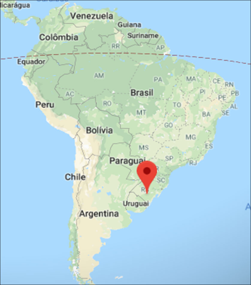
Figure 1. South America map showing the location of the study area, Minas do Camaquã (Camaquã Mines). Coordinate Location: 30°53’55”S 53°25’41”W.Source: Google Maps (2019).
Due to the use of new technologies for the exploration of ores, an ore concentration plant and a dam were built in the João Dias stream, which would be used to install an electric power generation turbine (Harres 2000). From 1981 onwards, the disposal of tailings from the Camaquã Mines, which until the year 1980 was improperly carried out on the banks of the João Dias stream and around Morro da Cruz, began to be carried out in a dam built in a meander of the state. João Dias stream course (Ronchi and Lobato 2000). Figure 2 shows how the tailings disposal was carried out in the João Dias stream until 1981.
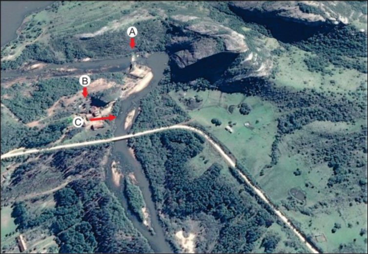
Figure 2. A: Tailings dam; B: Concentration plant; C: Waste path towards João Dias stream. Source: Von Ahn (2018).
This dam received the largest volume of mining tailings (4,243,310 m3) from the Camaquã Mines, occupying an area of 157.15 ha (Bruch 2014).
CAUSES AND EFFECTS OF DAM DISRUPTION
In 1981, several tailings spills occurred, the most significant in relation to sediment dispersion occurred on November 24 this year, due to the partial breakage of the tailings dam’s northern dam (Fernsterseifer and Hansen 2000).
Many surveys were conducted to ascertain the causes of the incident and all point to the obstruction of intermittent tributaries by the tailings dam, which under the heaviest rainfall conditions did not find a discharge valve and accumulated the rainfall load at its single spillway. Since it was not sized for large volumes of water, the rupture occurred, even though at the time the dam had few tailings compared to its capacity (Figure 3) (CBC 1984).
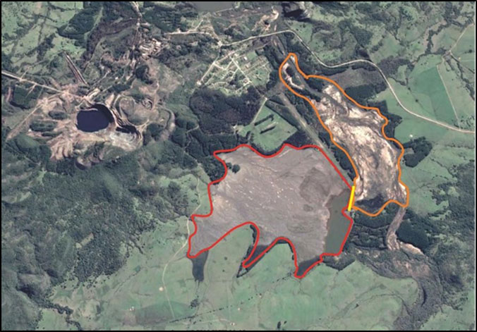
Figure 3. Tailings dam (red), ruptured mud (yellow) and ejected material in the João Dias stream (orange). Source: Google Earth (2019).
According to the study by Fensterseifer and Hansen (2000), the environmental impacts that occurred in the region were the generation of large rock blasting deposits, the opening of underground galleries, which are currently mostly occupied by water and an extensive deposit of materials. In addition, the silting of the João Dias stream due to the construction of the tailings dam was probably responsible for the high degree of sand accumulation, erosion-free soil and other materials carried by rain or wind to the bottom of the river.
The suspension of mining activities also generated a number of social problems, such as the marked evasion of residents of Vila Minas do Camaquã, who went to other locations in search of new job opportunities (Fensterseifer and Hansen, 2000).
With the deactivation of mining and, consequently, the end of the tailings deposition, CBC started the revegetation process with Pinus elliottii species in just 15 ha, about 9.55% of the total tailings dam area.
Deactivated open pit digs depict the marks of the exploration past, which are well defined in geographical space, as a result of a process of de-characterization of local natural cover (Figure 4).
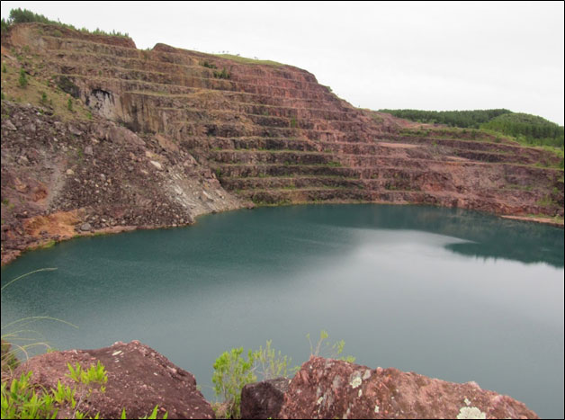
Figure 4. Inactive open pit in the Camaquã Mines. Source: Google Earth (2019). https://earth.google.com/.
Figure 4 shows that a large volume of rocks is exposed to oxidation processes, can generate acid drainages (AMD) with adverse effects on surface and groundwater quality (Figueiredo 2000).
In a visit to the Villa, carried out by the author in the company of eight geology lovers, in May 2019, it was possible to show that it is partially occupied, with much of the structure abandoned since the end of mining activities.
GEOLOGICAL CHARACTERISTICS OF JOÃO DIAS STREAM, AFFECTED BY TAILINGS DAM RUPTURED
The rock substratum of the João Dias stream is shown in Figure 5. The visual observation made in May 2019 showed that the area is composed of clastic sedimentary and volcanic rocks of the Camaquã Basin.
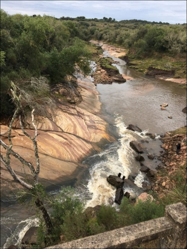
Figure 5. A view of João Dias stream showing the domain of clastic sedimentary rocks and fragments of these rocks.
The sediments deposited in the region correspond to compacted clay, sands, and distinct rock pebbles (Figure 6).
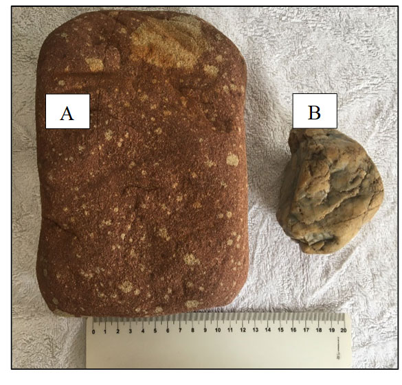
Figure 6. Samples of A: rock pebble; and B: milky quartz, collected at the João Dias stream.
The stream pebbles comprise granite, gneiss, subordinately quartz, quartzite, and reddish sandstone (Figure 6).
ENVIRONMENTAL MEASURES IMPLEMENTED IN THE CAMAQUÃ MINES
The data in Table 1 show that no action has been taken on the João Dias stream dam, which has been abandoned since 1990. It is noteworthy that the original dam structure is in poor condition, with a risk of rupture and may reach the bridge. RS-625 and the Camaquã River (Machado 2016). This demonstrates a lack of effective oversight by the responsible agencies, especially in the phase of decommissioning.
Table 1. Environmental measures implemented in the Camaquã Mines.
| Medium Affected | Measured | Procedures Adopted |
| Physical | – Monitoring of water resources;
– Implementation of the tailings dam effluent treatment plant. |
– Systematic collection at 19 points with physicochemical analysis;
– Dosage of flocculants and polyelectrolytes, mixture in baffles. |
| Biotic | – Forestation with exotic species;
– Urban afforestation; – Revegetation of tailings piles; – Forest nursery; – Cactus; – Revegetation of old tailings; – Pisciculture. |
– Planting pine and eucalyptus;
– Planting of exotic and native species; – Sowing of colonizing species; – Development of seedlings of native and exotic species; – Natural revegetation (Salso chorão). |
| Anthropic | – Environmental education. | – Prohibition of fishing and hunting;
– Distribution of guiding folders for the population; – audiovisual programs; – Dissemination in schools of municipal and state primary school. |
Source: Machado (2016).
Given this, Domingues (2016) recommends some measures to be adopted for the environmental management of the locality, as follows: (a) studies on the water quality in the tailings basin, João Dias stream and the mine pit; (b) studies on the presence of heavy metals or other toxic elements in the tailings pond, and their potential for contamination; (c) studies and actions to ensure the geological stability of the old mineral extraction galleries, to ensure safety in any visitation programs; and (d) actions to control dispersal and, if technically possible over time, to suppress exotic pine plots for their potential invasion.
Environmental diagnosis of the Camaquã Mines
The environmental diagnosis of the Camaquã Mines, performed by Bruch (2014) revealed that: there was effectiveness of the green walls (Pinus elliottii) in the containment of tailings mobilization to adjacent areas, especially for the Vila do Minas do Camaquã. Pinus elliottii has grown well even in soils with low organic matter and very acidic pH (close to 2). The waterproofing of the tailings dam soil and mud was efficient in the containment of percolated fluids, but the lack of maintenance of the spillway leads to the extravasation of fluids in rainy events, which leads to the João Dias stream; the soils are highly fragile to erosion and conservative practices should be adopted, especially in the litholics; Rendzic Chernosols, Hydromorphic Planosols and Red-Yellow Argisols are suitable; untreated domestic and rural sewage contributes to the degradation of water quality; water quality was better in areas with little or no land use for agricultural or mineral extraction activities; the levels of Pb, Cu and Fe were high; Pb presented concentrations ranging from 0.10 mg L-1 in the old tailings deposits near the British mill and 0.55 mg L-1 in the CBC tailings dam spillway; at the same sampling points, Cu presented concentrations of 0.254 mg L-1 and 0.180 mg L-1, respectively; Fe also followed Cu and Pb trends, with some points showing values below the geochemical background of 0.600 mg L-1; the highest Fe concentrations were found in the waters percolated by the sub-basin rocks; most samples fall into class 1 (noble uses of water) established by Resolution Nº 357/2005 of the National Environmental Council (CONAMA) (Brazil 2005); the Riograndense Sanitation Company (CORSAN) water intake dam showed high values of thermotolerant coliforms (1.638 NMP 100 mL-1) and low dissolved oxygen concentration (4.06 mg L-1 O2). All water samples are within the pH range of 6.0 to 6.99, which according to Sperling (2011) is low acid. The sample collected in the old tailing deposits from 1909 to 1975 on the banks of the João Dias stream showed the lowest value (pH 6.66). These results corroborate those obtained by Ronchi et al. (2000) who analyzed 19 variables related to João Dias stream water and showed that only four were above acceptable values, which allowed their inclusion in class 2 of CONAMA Resolution N° 20/1994. The assessment of water quality and sediment contamination of the João Dias stream indicated that although the fine fraction of sediments, which represents less than 3% of the total, was contaminated with Cu, water can be consumed with conventional treatment (Ronchi et al. 2000). The water quality in the municipality does not seem to have been affected by long mineral exploration.
CONCLUSIONS
Data from the literature review allowed us to infer that the main causes of the incident were the inability to contain tailings earlier than expected, unexpected rain, inability to flow, excess deformation and loss of mechanical stability of the tailings dam.
The environmental impacts resulting from the dam rupture were sedimented tailings, water and soil pollution, soil compaction, landscape degradation and habitat reduction.
Many of the impacts on the Camaquã Mines were due to the lack of effective measures by the regulatory agencies, which did not pay the necessary attention to compliance with the legislation, especially during the period of operation (mining). In this context, even in totally different proportions, it is impossible not to mention the tragedy that occurred in Mariana and Brumadinho, in the state of Minas Gerais, by the breaking of tailings dams, which caused countless deaths and still causes damage to all activities from those communities.
REFERENCES
Bettencourt J. S. 1992. A mina de cobre do Camaquã, RS. Tese (Doutorado). Universidade de São Paulo, São Paulo, 1992.
Brasil. Resolução CONAMA Nº 357, de 17 de março de 2005. Conselho Nacional de Meio Ambiente. Disponível em: <www.mma.gov.br/port/conama/res/res05/res35705.pdf>. Acesso em: 6 nov. 2019.
Brasil. Resolução CONAMA N° 20, de 18 de junho de 1996. Conselho Nacional de Meio Ambiente. Disponível em: https://www.unaerp.br/documentos/2225-resolucao-conama-20-1986/file. Acesso em 11 nov. 2019.
Bruch A.F. 2014. A mineração e a paisagem geoquímica da Sub-bacia hidrográfica do Arroio João Dias, Minas do Camaquã, Caçapava do Sul, RS. 303p. Tese de Doutorado (Doutorado em Geografia) Universidade Federal do Rio Grande do Sul, Porto Alegre, 2014.
Companhia Brasileira do Cobre (CBC). 1984. Controle Ambiental – Pontos de coleta de água. Relatório técnico interno – informativo, Minas do Camaquã – Caçapava do Sul, 9p.
Domingues S.A. 2016. Perspectivas de Valorização e Conservação do Patrimônio Geo-Mineiro da Localidade de Minas do Camaquã (Caçapava do Sul, Rs). 133p. Dissertação (Mestrado em Geografia e Geociências). Universidade Federal de Santa Maria. Santa Maria, 2016.
Fernsterseifer H.C., Hansen M.A.F. 2000. A Ordenação Territorial da Área de Destaque Ambiental Guaritas – Minas do Camaquã, RS. In: Minas do Camaquã, um estudo multidisciplinar. Organizado por Luiz Henrique Ronchi e Anderson Orestes Cavalcante Lobato. São Leopoldo: Ed. Unisinos, 2000, cap. 12, p. 273-305. Disponível em: http://www.unisinos.br/graduacao/bacharelado/geologia/minas_camaqua/cap12.pdf. Acesso em: 5 nov. 2019.
Figueiredo B.R. 2000. Minérios e ambiente. Campinas/SP, Ed. da Unicamp, 2000.
Harres M.M. 2000. Minas do Camaquã (Caçapava do Sul – RS): a exploração do cobre no Rio Grande do Sul. In L. H. Ronchi & A. O. C. Lobato (ed.) As Minas do Camaquã. São Leopoldo, Editora UNISINOS, 21-53.
Machado R.M. 2016. Modelo doutrinário e jurisprudencial para investigação de procedimentos minerários com ênfase na sustentabilidade ambiental. 142p. Dissertação (Mestrado em Tecnologia Mineral). Universidade Federal do Pampa, Caçapava do Sul, RS, 2016.
Nogueira J.E. 2012. Mineiros e Engenheiros: Memória, Identidade e Trabalho nas Minas do Camaquã entre 1970 e 1996. 196p. Dissertação (Mestrado em História). Universidade Federal de Santa Maria, Santa Maria, RS, 2016.
Ronchi L.H., Lobato A.O.C. 2000. Minas do Camaquã: Um estudo multidisciplinar. São Leopoldo: Ed. UNISINOS.
Ronchi L.B., Baecker C.A., Martins J. 2000. Avaliação do estado da qualidade das águas e da contaminação dos sedimentos recentes do Arroio João Dias após o encerramento das atividades das Minas do Camaquã – RS. In: Minas do Camaquã, um estudo multidisciplinar. Organizado por Luiz Henrique Ronchi e Anderson Orestes Cavalcante Lobato. São Leopoldo: Ed. Unisinos, 2000, cap. 10, p. 241 – 259. Disponível em: http://www.unisinos.br/graduacao/bacharelado/geologia/minas_camaqua/cap10.pdf. Acesso em: 11 nov. 2019.
Sperling E.von. 2011. Limnologia Aplicada. In: Programa de Pós-graduação em Saneamento, Meio Ambiente e Recursos Hídricos. Universidade Federal de Minas Gerais, Belo Horizonte/MG. 103p.
Von Ahn M.M. 2018. Análise Antropogeomorfológica em Geossítio da História da Mineração: estudo nas Minas do Camaquã – RS. 2018, 149f. Dissertação (Mestrado em Geografia) – Programa de Pós-graduação em Geografia, Instituto de Ciências Humanas, Universidade Federal de Pelotas, Pelotas, 2018.